Siyeh Pass
| Trail Features: | Outstanding views, Alpine meadows | 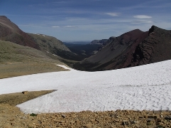 |
|||
| Trail Location: | Siyeh Bend | ||||
| Roundtrip Length: | 8.9 Miles | ||||
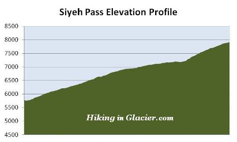
| Total Elevation Gain: | 2090 Feet | ||||
| Avg. Elev Gain / Mile: | 470 Feet | ||||
| Highest Elevation: | 7911 Feet | ||||
| Trail Difficulty Rating: | 13.08 (strenuous) | ||||
| Parking Lot Latitude | 48.70145 | ||||
| Parking Lot Longitude | -113.66959 | ||||
Trail Description:
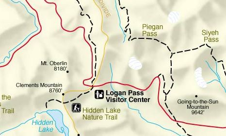
The hike to Siyeh Pass in Glacier National Park begins from the Siyeh Bend Trailhead, located 2.2 miles east of Logan Pass on the Going-To-The-Sun Road. Hikers also have the option of using the Piegan Pass Trailhead from the Jackson Glacier Overlook, but this would add a little more distance to your hike, and several hundred more feet of climbing. The Siyeh Bend Trail offers hikers a much more gradual climb to their destination.
From the Going-To-The-Sun Road, the Siyeh Bend Trail travels alongside Siyeh Creek for roughly two hundred yards before making a sharp right turn into the forest. At roughly 1.1 miles from the trailhead hikers will arrive at the Piegan Pass Trail junction. A turn to the right leads down to the Jackson Glacier Overlook. To continue towards Siyeh Pass hikers should turn left here.
The lower elevations of the hike pass through a dense spruce-fir forest. The forest, however, begins to thin out as you approach the Siyeh Pass Trail junction, located almost 2.7 miles from the trailhead. A turn towards the left at this junction will lead you up to Piegan Pass. To continue towards Siyeh Pass you should turn right onto the Siyeh Pass Trail.
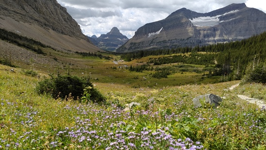
Roughly two-tenths of a mile beyond the junction hikers will enter Preston Park, a glacially-carved valley known for its incredibly beautiful meadows and abundant wildflowers. Preston Park is actually a series of high alpine meadows interspersed by stands of pine trees. The meadows become increasingly larger as you proceed further up the valley. If Siyeh Pass is impassable due to snow or bad weather, this would still be an excellent destination by itself.
You should note that bears are known to frequent the Preston Park area, so make sure you make a lot of noise, carry bear spray, and hike in groups.
As you continue up the trail you'll enjoy commanding views of 9365-foot Matahpi Peak towards the south. Piegan Mountain will dominate the view towards the west, while the pyramid-shaped Heavy Runner Mountain can be seen towards the southwest. Your destination becomes visible at this point as well. Siyeh Pass sits on the saddle between Matahpi Peak on your right, and 10,014-foot Mount Siyeh towards the north.
As if climbing the mountain wasn't enough of a thrill, a BASE jumper leapt off Mt. Siyeh in 1997, intending to land near Cracker Lake on the other side of the peak. Almost immediately after jumping the man hit a wall and his parachute became caught on a rock roughly 400 feet below the summit. A daring rescue involving 8 rangers and several other park employees pulled the man to safety, who suffered only minor injuries.
At roughly 3.5 miles the trail crosses Siyeh Creek. Shortly afterwards you'll begin the final climb up to Siyeh Pass. Over the course of the next nine-tenths of a mile hikers will climb almost 700 feet along a series of switchbacks. This will be the toughest section of the entire hike.
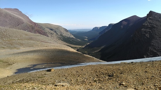
The top of the saddle represents the end of this hike. You'll reach your destination when you see a slightly faint side trail branching off near the south end of the saddle. This very short spur trail heads due east from a switchback on the main trail at an elevation of roughly 7900 feet. From this location the main trail continues to climb steeply for another 200 feet.
From this vantage point you'll be standing above a large snowfield that lies along the east side of the pass. You'll also enjoy commanding views of 8826-foot Goat Mountain, which dominates the landscape towards the east, as well as the Boulder Creek drainage towards the northeast.
The mountain and the pass were named by George Bird Grinnell for a Blackfoot Indian by the name of "Sai-yeh," which in the Blackfeet language means Crazy Dog, or Mad Wolf.
Siyeh Pass also has the distinction of being one of four sites in Glacier to have had a locomotive bell installed on it. In 1925, W. R. Mills, an advertising agent with the Great Northern Railway, and H. A. Noble, manager of the Glacier Park Hotel Company, requested permission from the park to 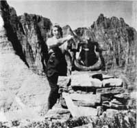 place locomotive bells on the summits of several passes in Glacier. According to Donald H. Robinson's Administrative History of Glacier National Park, the request was based on the old Swiss custom of placing bells on mountain tops and passes in order to allow hikers or horseback riders the unusual experience of ringing loud bells high in the mountains, as well as to let people in the valleys know that they had reached their destination.
In September of 1926 the request was finally granted to place bells at Swiftcurrent, Piegan and Siyeh passes. Three years later a fourth bell was added at Scenic Point in Two Medicine. The bells remained in place until the fall of 1943, when they were removed by the Hotel Company and donated to a World War II scrap metal drive. Ramble On: A History of Hiking discusses the fascinating story of why Glacier came to be associated with Swiss culture, and how it impacted the development of its extensive trail system during the early years of the park.
Hikers will have the option of continuing up the Siyeh Pass Trail as it ascends the northeastern slopes of Matahpi Peak. Over the next three-tenths of a mile the trail climbs 200 feet to reach a height of 8100 feet along one of the highest maintained trails in Glacier National Park. Once at the top you'll want to continue for another 100 yards or so to reach a vantage point that provides spectacular views of the Baring Creek Valley. You'll also have the option of continuing down the Siyeh Pass Trail for another 5.6 miles. This one-way semi-loop travels through the Baring Creek Valley before ending at Sunrift Gorge. For more information on this option, please click here.