Grinnell Glacier Overlook
| Trail Features: | Outstanding Views, Meadows, Wildflowers | 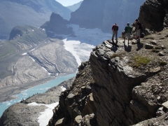 |
|||
| Trail Location: | Logan Pass | ||||
| Roundtrip Length: | 15.5 Miles | ||||
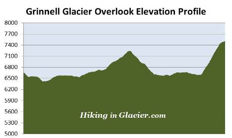
| Total Elevation Gain: | 2830 Feet | ||||
| Avg. Elev Gain / Mile: | 365 Feet | ||||
| Highest Elevation: | 7510 Feet | ||||
| Trail Difficulty Rating: | 21.16 (strenuous) | ||||
| Parking Lot Latitude | 48.69657 | ||||
| Parking Lot Longitude | -113.71813 | ||||
Trail Description:
The hike to the Grinnell Glacier Overlook in Glacier National Park begins from the Highline Trailhead, located on the north side of the Going-to-the-Sun Road at Logan Pass. To avoid the frequently full parking area at Logan Pass, you may want to consider taking the free shuttle up to the pass.
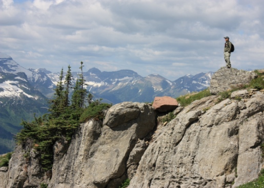
The Highline Trail is an extremely popular hike; and for good reason. At every step, and every turn, hikers will enjoy spectacular scenery as they traverse along the Continental Divide, also known as the Garden Wall throughout this section of Glacier National Park. The exceptionally beautiful views, the excellent opportunities for spotting wildlife, and the wildflowers, all combine to make this a hike you'll remember the rest of your life. Although it's a very strenuous hike, Grinnell Glacier Overlook is still a very popular destination.
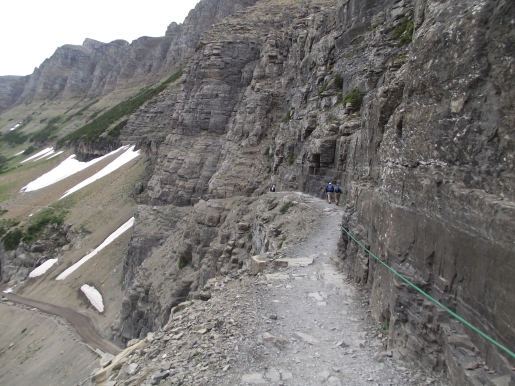
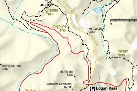
At roughly one-quarter of a mile from the trailhead hikers will arrive at the famous ledge with the reputation for terrifying those with a fear of heights. In most places the ledge, hanging like a shelf along the Garden Wall, is only six to eight feet in width, and has sheer drop-offs of roughly one hundred feet or more down to the Going-to-the-Sun Road below. This segment lasts for only three-tenths of a mile, but may seem forever if you have a fear of heights. Fortunately Glacier National Park has installed a hand cable along this stretch of the trail. My advice is to not let this deter you, as this is one of the most scenic hiking trails in America.
From the rimrock area the trail continues to hug the cliffs and slopes of the Garden Wall, and does so for most of its length to Granite Park. Throughout the early portions of the hike 8953-foot Mt. Cannon, 8179-foot Mt. Oberlin and 8986-foot Heavens Peak will dominate the views towards the west.
Roughly 2.5 miles from Logan Pass the slopes of the Garden Wall begin to moderate. Soon you'll begin a short, but relatively steep climb up to Haystack Pass. At 3.6 miles, after climbing roughly 275 feet along one long switchback, hikers will reach the pass. At an elevation of 7024 feet the pass forms the saddle between 7486-foot Haystack Butte and the Garden Wall, which at this point is technically the southeastern flank of Mt. Gould. With its outstanding panoramic views of the upper McDonald Creek Valley, Haystack Pass is also a popular spot for an extended break.
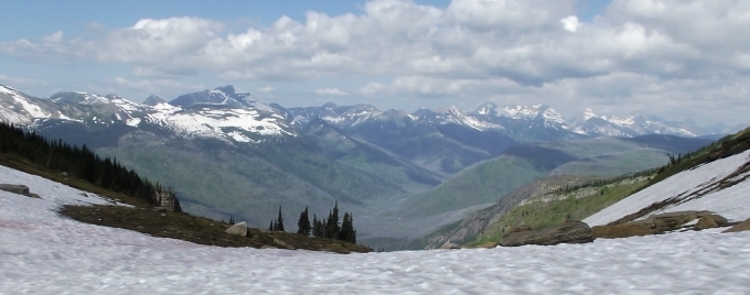
Beyond the pass the trail continues to ascend along the Garden Wall. Soon you'll reach the highest point on this stretch. After topping out at an elevation of roughly 7280 feet the trail begins descending towards Granite Park. As you proceed, 8436-foot Swiftcurrent Mountain will eventually come into view looking towards the north.
At 6.9 miles hikers will reach the Garden Wall Trail, which will lead you to the Grinnell Glacier Overlook atop the Garden Wall. The Highline Trail continues towards the Granite Park Chalet, located roughly seven-tenths of a mile away.
From the junction the trail climbs steeply towards the overlook. Hikers will ascend more than 900 feet in less than nine-tenths of a mile. The climb is mostly steady, but there are a few sections that are very steep. Trekking poles were definitely helpful during our descent from the overlook. Like much of the Highline Trail, the Garden Wall Trail is a relatively narrow path with steep drop-offs in many places. However, it's nothing more dangerous than what you've already experienced on the Highline. As you ascend you may notice Jackson and Blackfoot Glaciers in the far-off distance towards the south.
At roughly 7.75 miles hikers will finally reach Grinnell Glacier Overlook. From the top of the Continental Divide you'll enjoy a commanding birds-eye view of The Salamander, Grinnell Glacier, Upper Grinnell Lake, Allen Mountain, Angel Wing and Mt. Gould. The glacier in the foreground in the photo below is known as The Salamander. Partially hidden by the rock ledge, but visible at the far end of Upper Grinnell Lake is Grinnell Glacier. Mt. Gould, which tops out at 9554 feet, rises high above the far end of the glacier.
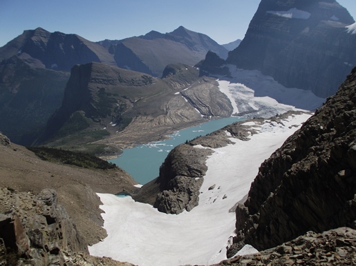
The overlook straddles the narrow crest of the Garden Wall. Geologically speaking, the Garden Wall is an arête, which is defined as a thin ridge of rock separating two valleys that have been carved by glaciers. In this case, the Garden Wall separates Granite Park from the Grinnell Glacier drainage.
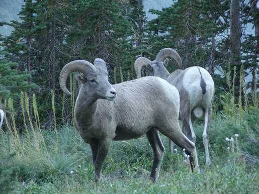
As we sat atop the narrow divide two mountain goats suddenly appeared out of nowhere. At first appearing to charge us, a nanny and a kid raced past within ten feet of our group as we sat spellbound, with virtually no time to react.
The overlook stands roughly one thousand feet above Grinnell Glacier, which was discovered in 1885 by George Bird Grinnell, an early American conservationist, explorer, writer and founder of the Audubon Society. Grinnell was so inspired by the scenery he saw during his first visit to the area that he spent the next two decades working to establish it as a national park.
In 1850, at the end of what has been referred to as the Little Ice Age, Grinnell Glacier, combined with The Salamander, measured 710 acres in surface area. As of 2005 the now separated glaciers cover less than 200 acres. Interestingly, during his final visit to the glacier in 1926, Grinnell noted in his diary that "the glacier is melting very fast and the amount of water coming from it is great. All these glaciers are receding rapidly and after a time will disappear."