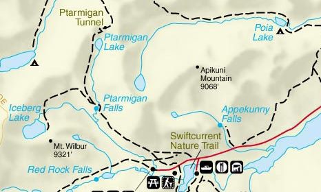
Ptarmigan Tunnel
| Trail Features: | Outstanding views, Alpine Lake, Historic | 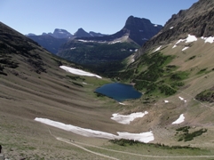 |
|||
| Trail Location: | Iceberg Lake Trailhead | ||||
| Roundtrip Length: | 10.7 Miles | ||||
| Total Elevation Gain: | 2300 Feet | ||||
| Avg. Elev Gain / Mile: | 430 Feet | ||||
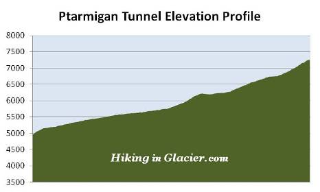
| Highest Elevation: | 7255 Feet | ||||
| Trail Difficulty Rating: | 15.30 (strenuous) | ||||
| Parking Lot Latitude | 48.79958 | ||||
| Parking Lot Longitude | -113.67924 | ||||
Trail Description:
The hike to Ptarmigan Tunnel in Glacier National Park begins behind the cabins near the Swiftcurrent Motor Inn. There's enough parking for roughly 12-15 cars in the lot next to the trailhead. However, given the popularity of the area, it's likely the lot will be full, in which case you'll have to park in front of the Swiftcurrent Motor Inn. This will add a walk of another two-tenths of a mile to reach the trailhead.
Just beyond the Iceberg Lake Trailhead hikers will immediately turn right at a junction to access the short connector trail that leads to the Ptarmigan Trail. This connector makes a fairly steep climb, gaining roughly 185 feet in only a quarter-of-a-mile. However, once on the Ptarmigan Trail, the grade becomes much more moderate.
 Upon reaching the Ptarmigan Trail junction hikers should turn left. A turn to the right will lead you down to the Many Glacier Hotel.
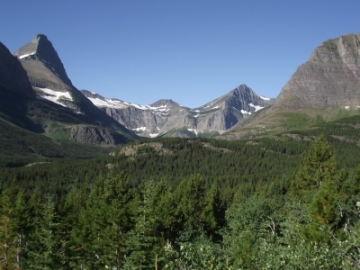
Along the upper reaches of the connector trail, as well as on the early sections of the Ptarmigan Trail, hikers will enjoy commanding views of 8851-foot Mount Grinnell and 8436-foot Swiftcurrent Mountain towards the southwest. The dominating feature towards the west is 9321-foot Mount Wilbur, and lying towards the northwest, in the direction you're heading at this point, is the Ptarmigan Wall.
The Many Glacier area, especially along the Ptarmigan Trail corridor, is located in prime bear habitat. The first mile or so past the connector is a haven for grizzly bears. Nearly every time that I've hiked this trail I've spotted at least one along the hillside. It's extremely important for hikers to make a lot of noise, carry bear spray, and hike in groups in this area. As a result of its location, hiking trails in the Many Glacier area are frequently closed due to bear activity. Thus, it's always a good idea to check with a ranger on the status of a trail before proceeding on any hike in the park.
The first segment of the hike passes through open terrain that offers grand views of the surrounding mountains. However, as you proceed further along, the trail enters a fairly dense pine forest roughly 1.5 miles from the trailhead.
At 2.5 miles hikers will reach a small clearing overlooking Ptarmigan Falls. Unfortunately this is the best view of the falls you'll have, as steep terrain makes it virtually impossible to get a closer look. Moreover, tree cover blocks a full view of the falls from top to bottom.
Just above Ptarmigan Falls is an open and rocky area that's become a popular spot for a quick snack break or an extended rest stop. Shortly after passing the falls you'll cross a footbridge over Ptarmigan Creek. Roughly a tenth-of-a-mile later you'll reach the Iceberg Lake Trail junction, which takes hikers to one of the most beautiful alpine lakes in the park. Turning right and continuing on the Ptarmigan Trail will lead hikers to the Ptarmigan Tunnel. With most people heading towards Iceberg Lake, this segment of the trail won't be nearly as heavily traveled as the first section.
Beyond the junction hikers will begin another fairly steep climb of more than 400 feet over the next six-tenths of a mile. This section also passes through a thick patch of huckleberries. This is another place where you'll need to make a lot of noise in order to avoid a surprise encounter with a bear.
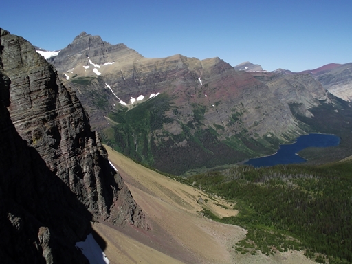
Once this relatively short ascent is completed, the saddle above the Ptarmigan Tunnel will be directly ahead of you. Shortly thereafter you'll emerge from the treeline and views of the Ptarmigan Wall will become even more dramatic. The Ptarmigan Wall, towering more than 1700 feet above the trail at this point, is known as an arête, which is defined as a thin ridge of rock separating two valleys that have been carved by glaciers. In this case, the Ptarmigan Wall separates the Many Glacier valley from the Belly River valley.
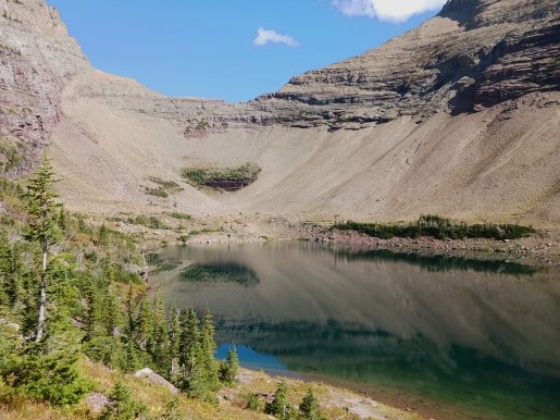
Roughly 4.2 miles from the trailhead you'll reach a series of waterfalls and cascades tumbling down Ptarmigan Creek in the valley below the trail. Just beyond this point is Ptarmigan Lake. Although the main trail continues above the shore, there's a short side trail that drops down to the foot of the lake. Bighorn sheep and mountain goats are frequently seen in this area.
From here you can see the final segment of the trail as it climbs two major switchbacks towards the tunnel. Some might find this climb a little daunting. Above the lake the trail gains roughly 500 feet in less than two-thirds of a mile. However, the spectacular views that await you from both sides of the tunnel should provide enough motivation to push you onward.
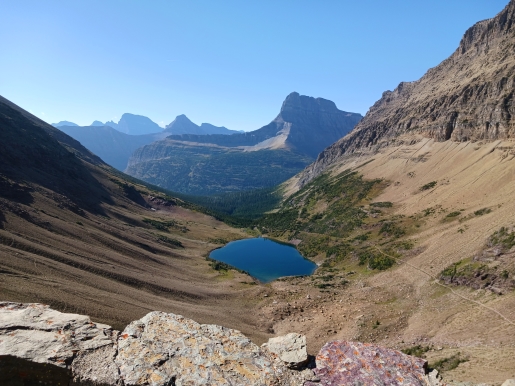
Upon arrival at the tunnel's south entrance hikers will enjoy commanding views of Ptarmigan Lake and the glacially sculpted, U-shaped valley between the Ptarmigan Wall and Crowfeet Mountain. Beyond the valley, Mt. Wilbur is the dominating feature.
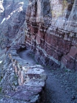
Walking to the other side of the tunnel is like walking into another world. Hikers will have stunning views of Natoas Peak, Crosley Ridge, and the Belly River as it flows into Elizabeth Lake. Walk a little further down the trail, as it hugs the red rock face of Crowfeet Mountain, and you'll be able to see Old Sun Glacier on the slopes of 10,004-foot Mt. Merritt towards the west.
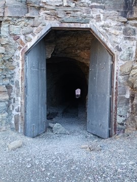
The 240-foot Ptarmigan Tunnel was originally built by the Civilian Conservation Corp in the 1930's for horses and early park tours. Using two opposing steel jackhammers drilling from either side of the tunnel, and a series of dynamite charges, workers broke through the mountain in less than three months. The blasted rock was used to build doorway entrances, also known as adits, on each end of the tunnel, as well as retaining walls alongside the trail. In 1975 the National Park Service added steel doors to both ends of the tunnel, which now remain closed between October 1st and the opening of the trail, usually around the middle of July.
In 1998 a woman lost her life on the north side of Ptarmigan Tunnel in one of the most freakish accidents in Glacier National Park history. The Polson, Montana woman, along with her husband and two companions, rode horseback to the tunnel from Many Glacier. Upon arrival they led their horses through the tunnel to view the scenery on the other side. While standing beside the low stone parapet her horse abruptly jerked and stumbled, and knocked the woman onto the retaining wall. The horse then lost its footing and fell on top of her. Both horse and rider then rolled over the wall before falling hundreds of feet to their deaths.