Hidden Lake
| Trail Features: | Outstanding views, Alpine meadows, Lake | 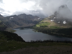 |
|||
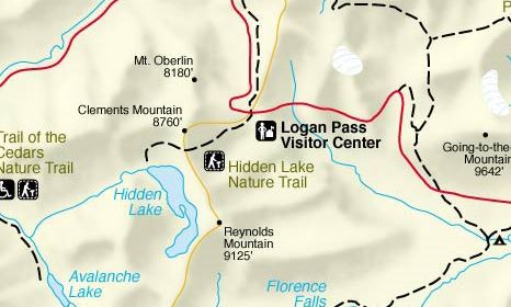
| Trail Location: | Logan Pass Visitor Center | ||||
| Roundtrip Length: | 5.4 Miles | ||||
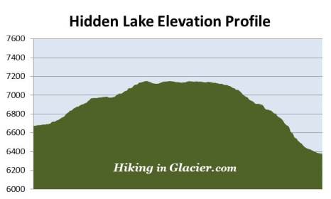
| Total Elevation Gain: | 1325 Feet | ||||
| Avg. Elev Gain / Mile: | 491 Feet | ||||
| Highest Elevation: | 7152 Feet | ||||
| Trail Difficulty Rating: | 8.05 (moderate) | ||||
| Parking Lot Latitude | 48.69539 | ||||
| Parking Lot Longitude | -113.71826 | ||||
Trail Description:
The hike to Hidden Lake in Glacier National Park begins from the west side of the Logan Pass Visitor Center. Once on the back side of the visitor center, after climbing the stairway, stay towards the right and look for the Hanging Gardens Trailhead. The trail is more commonly referred to as the Hidden Lake Nature Trail.
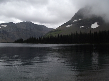
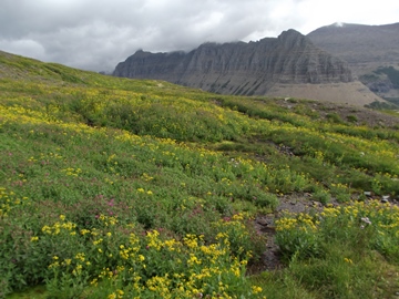 The entire length of this hike is completely open and exposed to the elements. As you ascend across the alpine meadows known as the Hanging Gardens you should expect a variety of weather conditions, including sun, wind, rain and cooler temperatures. You should also expect extreme crowds, as the Hidden Lake Overlook area is one of the most popular destinations in Glacier. As a result, parking is usually an issue during peak tourist season. If you wish to avoid the crowds I highly recommend starting your hike as early in the morning as possible, or using the park's free shuttle system.
The hike begins along a paved surface that quickly turns into a raised boardwalk after walking a short distance. At this lofty elevation snow tends to linger around well into the summer. The boardwalk helps to keep hikers above the snow, slush, mud and rivulets. Once the snow melts, however, the Hanging Gardens becomes an incredibly beautiful carpet of wildflowers.
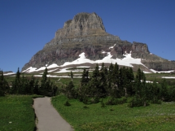 As you proceed upwards during the early portions of your hike, 8760-foot Clements Mountain will dominate the landscape directly in front of you (see photo on right). Looking towards the north, on your right, hikers will enjoy outstanding views of the Garden Wall (see photo above). Standing towards the northwest is 8180-foot Mt. Oberlin.
A little more than a half-mile from the visitor center, after climbing a series of wooden steps, hikers will reach the end of the first boardwalk section. From here the trail shifts to a more southwesterly course, and begins heading in the direction of Bearhat Mountain. Both 9125-foot Mt. Reynolds and 8016-foot Heavy Runner Mountain will be on your left as you proceed along this stretch.
Even relatively late into the season it's possible you'll have to traverse across a couple of small snowfields as you ascend towards Hidden Lake Pass.
At just over a mile from the trailhead hikers will reach a small rise, and then shortly thereafter will pass a couple of small ponds on your left. Between these two ponds is an unmarked trail that leads to the Dragon's Trail, which also offers spectacular views of Hidden Lake. Just beyond this section, roughly 1.2 miles from the trailhead, hikers will reach the Continental Divide where runoff from snow and rain begins flowing towards the Pacific Ocean.
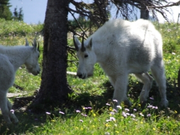
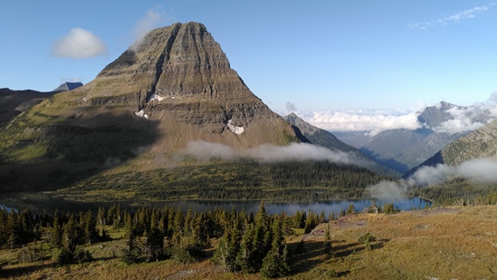
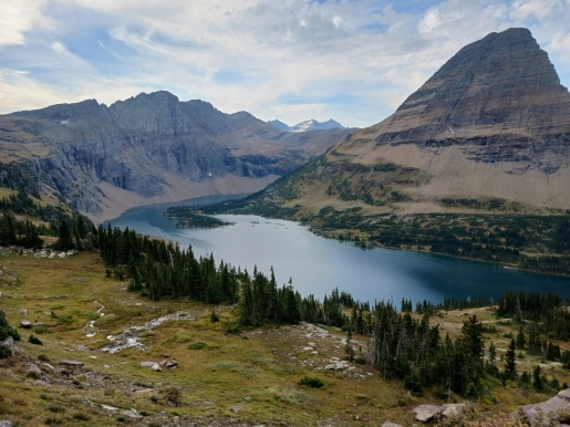
At 1.35 miles hikers will arrive at the Hidden Lake Overlook where you'll enjoy outstanding panoramic views of the lake and surrounding mountains. From this vantage point 8684-foot Bearhat Mountain is the dominating feature above Hidden Lake. Looking directly towards the west is 8952-foot Mount Cannon. Towards the south is 8750-foot Fusillade Mountain, and towards the southwest you'll be able to see Gunsight Mountain and Sperry Glacier in the far off distance. Mountain goats are fairly common in the area surrounding the overlook. You should also keep an eye out for bighorn sheep, marmots, and even wolverines. Grizzly bears are also occasionally seen in the area as well.
Soon after passing the overlook the trail begins descending along the southern slopes of Clements Mountain. As you proceed downward you'll enjoy excellent views of the lake, as well as Mt. Brown, Mt. Stanton and the upper portions of the Lake McDonald valley towards the west.
As you continue to descend the route becomes progressively steeper as you get closer to the lake, and eventually begins traveling down a series of switchbacks. In all, the trail drops roughly 770 feet from the overlook to the lakeshore.
At roughly 2.7 miles hikers will finally reach the northwest corner of Hidden Lake. There's a small beach area that extends in either direction, and offers hikers the opportunity to do a little exploring around the glacially-carved lake, or possibly find a more secluded location for lunch. If needed, there are pit toilets near the end of the trail.
Dominating the views from the shoreline will be Bearhat Mountain on your right and Reynolds Mountain towards the left, while Fusillade Mountain and the Dragon's Tail lie directly across the lake. Hidden Lake is also a popular destination for anglers. Perhaps the most famous person to ever visit Hidden Lake was George H. W. Bush. In 1983 the then-Vice President hiked to the shores of the lake to fish for trout.