Upper Two Medicine Lake
| Trail Features: | Lake views, Meadows, Wildflowers | 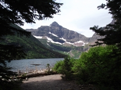 |
|||
| Trail Location: | Two Medicine Boat Dock | ||||
| Roundtrip Length: | 4.8 Miles | ||||
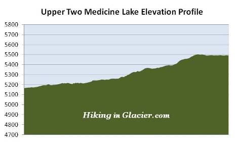
| Total Elevation Gain: | 350 Feet | ||||
| Avg. Elev Gain / Mile: | 146 Feet | ||||
| Highest Elevation: | 5505 Feet | ||||
| Trail Difficulty Rating: | 5.50 (moderate) | ||||
| Parking Lot Latitude | 48.48381 | ||||
| Parking Lot Longitude | -113.36954 | ||||
Trail Description:
Hikers have the option of starting their hike to Upper Two Medicine Lake from either the North Shore Trailhead at the Two Medicine Campground, or the South Shore Trailhead at Two Medicine Lake. However, you can shave roughly 4.8, or 6.4 miles, respectively, off your roundtrip hike by taking the shuttle boat across Two Medicine Lake. The following describes the hike for those taking the boat to the west end of the lake. Please note that there is a fee for the shuttle ride.
After arriving at the boat landing your hike begins with a walk along a short section of boardwalk that passes over a sensitive, boggy area. Although I've never seen one here, this is likely a good place to spot a moose, especially during the morning hours. A short distance later you'll arrive at the South Shore Trail junction, which connects hikers with the Two Medicine Pass Trail. To continue towards the lake you should proceed straight ahead here.
The early portions of the hike passes through an area thick with ferns, thimbleberries and huckleberries.
Roughly three-quarters of a mile from the boat landing the trail crosses a footbridge. A short distance later you'll reach the North Shore Trail, which connects hikers to the Dawson Pass Trail. Hikers should proceed straight ahead at this juncture, which now becomes the Upper Two Medicine Lake Trail.
Just past the junction the 7620-foot Pumpelly Pillar comes into view, which will be directly in front of you at this point. The glacially carved, cone-shaped rock is named after Raphael Pumpelly, leader of the Northern Transcontinental Railway Survey party that crossed Pitamakan Pass in 1883. As you continue along the trail, above Twin Falls, Pumpelly Pillar will be on your right, but the views of the mountain aren't quite as dramatic as they are from this frontal view.
Roughly one mile from the trailhead you'll reach another creek crossing. Just beyond this point is the side trail that leads to Twin Falls. It's an easy walk of less than a tenth-of-a-mile to reach the falls from this junction. To continue on towards Upper Two Medicine Lake, hikers should proceed straight ahead.
Roughly 1.5 miles from the trailhead hikers will emerge from the dense forest, and into a transition zone between small meadows and small groves of trees. After walking another third-of-a-mile you'll emerge onto a large open meadow. From this point forward the trail passes through open terrain with numerous wildflowers and several nice thimbleberry patches along the way.
As you proceed along this section of trail, take a look behind you and you'll see Scenic Point, which is near the top of the mountain that dominates the view in the far off distance (towards the east). Look for a slab of rock jutting out towards the north, near the top of the mountain. This vantage point offers commanding views of the entire Two Medicine Valley, including Upper Two Medicine Lake.
 Before reaching a small beach area on the east side of the lake, hikers must first pass through the Upper Two Medicine Lake backcountry campground. The campground contains four individual campsites, two of which can be reserved in advance.
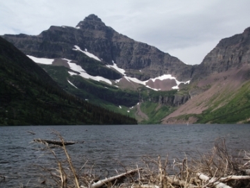
At an elevation of just under 5500 feet, the Upper Two Medicine Lake is the highest in a series of three glacially fed lakes that dominate the Two Medicine Valley. The Upper Two Medicine Lake is 1.1 miles in length, has a maximum width of two-tenths of a mile, and has a surface area that covers 155 acres. The lake sits in a large basin surrounded by the jagged rocks of four mountains: 9272-foot Mt. Rockwell to the south, 8538-foot Mt. Helen and Pumpelly Pillar towards the north, and 8502-foot Lone Walker Mountain, which dominates the view at the end of the lake towards the southwest (see nearby photo). Traversing along the top of Mt. Helen, Lone Walker and Mt. Rockwell is the Continental Divide.
My book, Ramble On (a history of hiking), contains an extensive section on the development of trails and hiking culture in America's first tourist destinations, national forests and national parks.