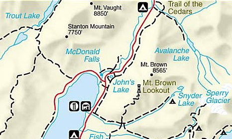
Upper McDonald Creek Trail
| Trail Features: | Waterfalls, Scenic Views | 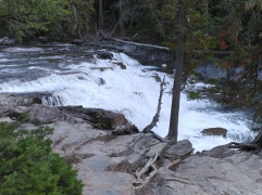 |
|||
| Trail Location: | Upper McDonald Creek Trailhead | ||||
| Roundtrip Length: | 5.3 Miles | ||||
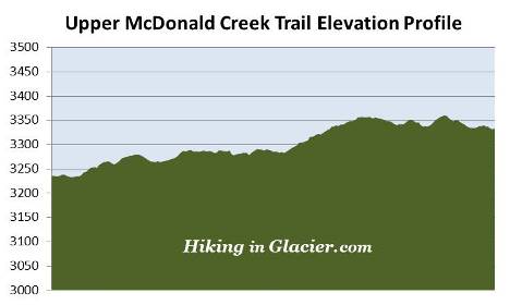
| Total Elevation Gain: | 210 Feet | ||||
| Avg. Elev Gain / Mile: | 79 Feet | ||||
| Highest Elevation: | 3360 Feet | ||||
| Trail Difficulty Rating: | 5.72 (moderate) | ||||
| Parking Lot Latitude | 48.63728 | ||||
| Parking Lot Longitude | -113.86843 | ||||
Trail Description:
The hike along the Upper McDonald Creek Trail in Glacier National Park begins from the Upper McDonald Creek Trailhead. To reach the trailhead from the Lake McDonald Lodge, hikers should drive eastbound along the Going-to-the-Sun Road for roughly 1.5 miles to reach the turn off for North Lake McDonald Road, which will be on your left. The trailhead will be located on the right side of the road, roughly three-tenths of a mile from the Going-to-the-Sun Road. The pull-off at the trailhead can accommodate a handful of cars. Hikers can also park at the pull-off near the bridge over McDonald Creek, or in the large lot located at the junction of North Lake McDonald Road and the Going-to-the-Sun Road.
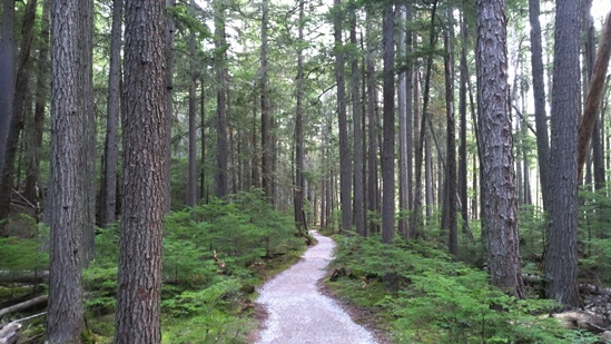
The hike begins by traveling along a gravel footpath through a dense, old-growth forest. Throughout the entire route hikers will pass through a lush green forest more normally found on the Pacific Coast. Being situated on the eastern edge of the maritime climate of the Pacific Northwest, the Lake McDonald Valley also marks the extreme eastern limits for giant western hemlocks and western red cedars. The humidity in this valley allows red cedars to grow to heights of 100 feet, and diameters of 4 to 7 feet. Some of the trees throughout this area are estimated to be more than 500 years old. Look closely and you'll also notice the lush green of ferns and mosses growing along the forest floor.
Roughly three-tenths of a mile from the trailhead hikers will reach the spectacular McDonald Falls. If you're hiking this trail during the spring, keep an eye out for harlequin ducks. Although they spend most of their lives along the rocky coastal waters of North America, these small sea ducks migrate inland during the spring to breed and raise their young along turbulent freshwater streams. Though somewhat rare, the Upper McDonald Creek has the highest density of breeding harlequins in the lower 48 states.
 At roughly one-half mile hikers will reach the horse path junction. You should proceed straight ahead to continue along the Upper McDonald Creek Trail. After walking another quarter-mile hikers will reach Sacred Dancing Cascades. The cascade receives its name from a Kootenai phrase meaning "a good place to dance", or "where people dance". After soaking in the beautiful scenery you should continue straight ahead at this junction. As an option for your return trip, you could cross over the fairly long footbridge here, and then return to the trailhead via the John's Lake Loop. This will add roughly one more mile to your overall trip mileage.
At just over 1.4 miles hikers will reach a fairly large wetland area alongside an oxbow bend on McDonald Creek. In addition to being a great place to spot waterfowl, this area is prime moose habitat. The best time to possibly spot one is in the morning or early evenings.
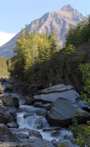
From the wetland area the trail abruptly swings away from the creek. After traveling through the dense forest for roughly a mile, the trail begins to run parallel to the creek once again. After walking a short distance you’ll pass Avalanche Creek Overlook, a wooden platform that overlooks the creek on the opposite bank. The trail continues for a short distance beyond this point, until reaching a boulder field and a low rock outcropping that stands a few feet above the creek. This outcropping marks the end of the trail. From this perch you'll enjoy the rushing waters of McDonald Creek, and is perfect place to enjoy a picnic lunch. Looking upstream 8952-foot Mount Cannon rises almost 5600 feet above the valley floor, and dominates the view here.
Despite the warning at the trailhead we saw very minimal damage from the Howe Ridge Fire. The lightning-ignited wildfire burned more than 14,500 acres along the north and northwest sides of Lake McDonald in 2018.