
Swiftcurrent Pass
| Trail Features: | Outstanding views, Alpine Meadows, Lakes | 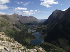 |
|||
| Trail Location: | Swiftcurrent Pass Trailhead | ||||
| Roundtrip Length: | 14.2 Miles | ||||
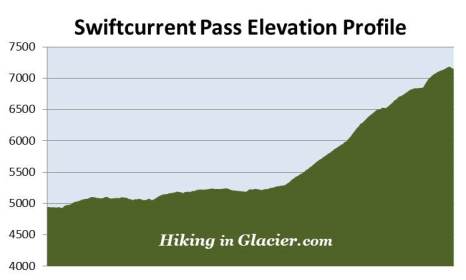
| Total Elevation Gain: | 2400 Feet | ||||
| Avg. Elev Gain / Mile: | 338 Feet | ||||
| Highest Elevation: | 7185 Feet | ||||
| Trail Difficulty Rating: | 19.0 (strenuous) | ||||
| Parking Lot Latitude | 48.79763 | ||||
| Parking Lot Longitude | -113.67854 | ||||
Trail Description:
The hike to Swiftcurrent Pass in Glacier National Park begins from the Swiftcurrent Pass Trailhead in Many Glacier. The trailhead is located at the far end of the parking area for the Swiftcurrent Motor Inn at the end of Many Glacier Road.
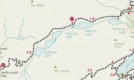
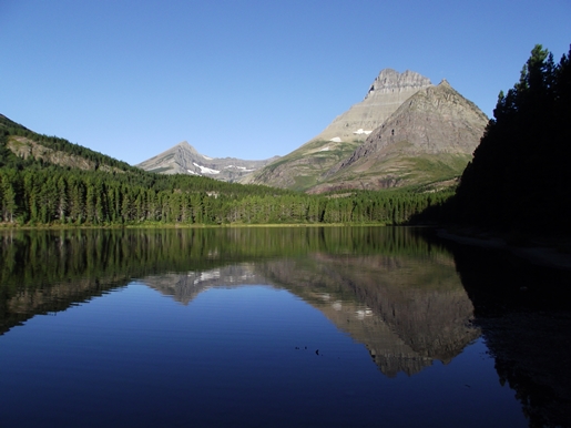
A short distance from the normally busy parking lot the trail crosses over Wilbur Creek. After walking roughly one-third of a mile hikers will reach the side path that leads to Fishercap Lake, the first destination on this hike. From this junction it's a very short walk of less than a hundred yards to reach its northern shore. Although some might bypass this gem, it's well worth the trip, as the views from the lake are quite stunning. Fishercap Lake is also a great place to spot a moose. The lake's name is a reference to George Bird Grinnell, whom the Blackfeet Indians called "Fishercap".
For the most part the trail travels under the canopy of the forest as it makes its way towards Bullhead Lake; however, there are several open areas along the way that provide outstanding views of the surrounding mountains. You'll also pass through several patches of thimbleberries and huckleberries that can make for some tasty snacks when in season. Although this is a very popular hiking trail, hikers should still make plenty of noise to warn any bears that might be around that you're passing through their territory. It's also a good idea to carry bear spray as well.
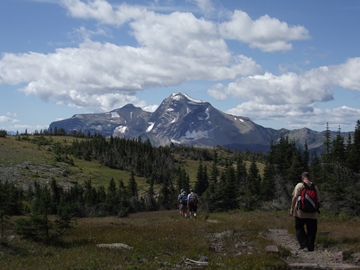
At 1.7 miles hikers will reach Redrock Lake, the second destination on this hike. The views from this lake are also quite outstanding. Here you'll enjoy commanding views of 8851-foot Mt. Grinnell and Swiftcurrent Glacier towards the southwest, and 8436-foot Swiftcurrent Mountain almost directly towards the west. If you look closely you may be able to spot the fire tower atop Swiftcurrent Mountain.
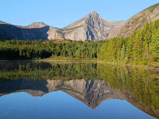
From this point the trail proceeds along the northern shore of the lake. As you make your way around to the far western shore you'll pass some of the red rock formations that provided the inspiration for the naming of the nearby lake and falls.
At just over 2 miles hikers will reach an unmarked split in the trail. Walking a short distance along the left fork will lead you down to Redrock Falls, which are actually a series of cascades, and in my opinion, one of the more picturesque waterfalls in Glacier National Park. Upon arrival at the lower falls you'll notice several social trails leading to various vantage points that offer views of the lower and upper falls.
After returning back to the main trail you'll continue for a very short distance before reaching a viewpoint of the highest falls in the series. Swiftcurrent Mountain will provide the backdrop for a picture-perfect scene here.
As a result of the lakes, stream, and an abundance of willows, the entire Swiftcurrent Valley is excellent habitat for moose. You'll have a great chance of spotting one almost anywhere in this valley, including right alongside the trail.
At roughly 3.4 miles the trail crosses over a suspension bridge. Soon afterwards hikers will reach a side trail that leads down to Bullhead Lake. Hikers will have the option of walking down this social path for about a tenth-of-a-mile, or staying on the main trail and continuing for another tenth-of-a-mile to reach the shore of the lake. In my opinion the views from the social trail are much better.
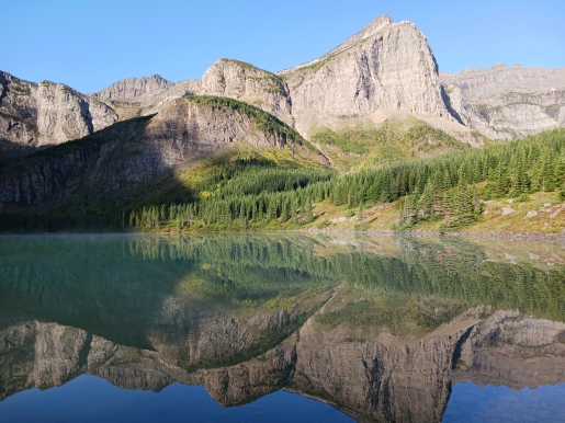
From the northeastern shore of Bullhead Lake hikers will enjoy outstanding views of 8436-foot Swiftcurrent Mountain, Swiftcurrent Glacier, as well as the headwall above the lake. At this point you might be asking yourself in which direction does the trail go, and exactly how you're going to be able to make it up to the pass. No doubt, it looks pretty daunting from this vantage point!
Beyond the lake the trail travels through another long stretch of willows thickets, which means this area is also excellent habitat for moose. In fact, we saw four in this vicinity on our most recent hike.
At roughly 4.1 miles the Swiftcurrent Pass Trail crosses the second of two footbridges. This marks the spot where the real fun begins, as you will almost immediately begin the steep climb up the headwall. As you ascend along the first couple of switchbacks you'll pass through several long stretches of thimbleberry and huckleberry patches. This is another good place to make a lot of noise to alert any bears that might be around.
At just over 5 miles the trail begins to ascend above the scrub pines where you'll enjoy unobstructed views of the Swiftcurrent Valley. The trail also becomes progressively steeper, and over the course of the next mile or so you'll be exposed to some very long drop-offs. If you're uncomfortable with heights, or you're simply running out of gas, this isn't a bad place to end your hike. Even here the views of the Swiftcurrent Valley are quite spectacular.
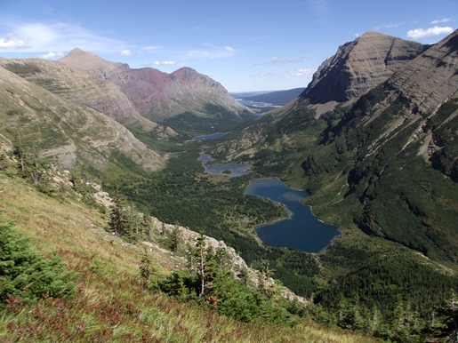
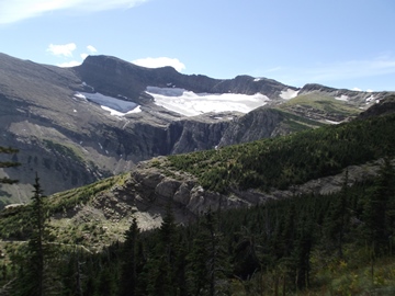
As you continue to climb the trail passes near a waterfall cascading several hundred feet off Swiftcurrent Glacier. From here the trail makes a sharp turn towards the northeast. The entire chain of lakes in the Swiftcurrent Valley will be visible along this stretch. This includes Bullhead, Redrock, Fishercap and Swiftcurrent, as well as Lake Sherburne in the far-off distance. Looking towards the north Windmaker Lake will soon become visible as well. Looking back towards the south you'll enjoy an outstanding view of Swiftcurrent Glacier.
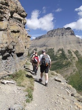
During this stretch the path becomes fairly narrow, while passing over some very steep drop-offs. Soon you'll pass around a bend in the cliff known as the Devil's Elbow (see photo below). This is a fairly long stretch of trail where you'll have to exercise caution and pay close attention to your footing. If you have vertigo, or a fear of heights, you may want to consider another hike.
At roughly the 6.1-mile mark the trail finally levels-out, and for the next four-tenths of a mile will follow along fairly moderate terrain before making one final push to the top of the pass.
At just over 7 miles, and an elevation of roughly 7185 feet, hikers will finally reach the top of Swiftcurrent Pass. You'll definitely want to continue down the trail for another hundred yards or so to reach the side trail that leads to the fire lookout atop Swiftcurrent Mountain. From this junction you'll enjoy outstanding views of 8987-foot Heavens Peak towards the southwest. The Highline Trail will be 0.6 miles away, while the Granite Park Chalet is still another 0.9 miles away. The 1.4-mile side path that leads to the Swiftcurrent Fire Lookout climbs roughly 1250 feet, and is the highest maintained trail in Glacier National Park.
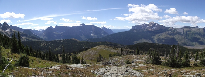
If you still have the time and energy, I highly recommend continuing for another quarter-mile along the main trail to a rocky outcropping that provides spectacular views of Granite Park, Heavens Peak, Mt. Cannon and Mt. Oberlin, as well as the area around Logan Pass.