Sperry Chalet
| Trail Features: | Outstanding views, Waterfalls | 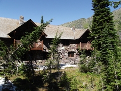 |
|||
| Trail Location: | Lake McDonald Lodge | ||||
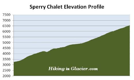
| Roundtrip Length: | 12.3 Miles | ||||
| Total Elevation Gain: | 3360 Feet | ||||
| Avg. Elev Gain / Mile: | 546 Feet | ||||
| Highest Elevation: | 6560 Feet | ||||
| Trail Difficulty Rating: | 19.02 (strenuous) | ||||
| Parking Lot Latitude | 48.61686 | ||||
| Parking Lot Longitude | -113.87554 | ||||
Trail Description:
The hike to the Sperry Chalet in Glacier National Park begins from the Sperry Trailhead, located across the road from the Lake McDonald Lodge. In a very short distance, after passing the horse path, the trail becomes known as the Gunsight Pass Trail.
Almost immediately the trail begins climbing, passing through an old growth forest of red cedar, western larch and hemlock along the lower elevations, to a dense spruce-fir forest as it ascends higher. Many hikers and horses will be sharing this heavily used segment of the trail as they head up to Sperry Chalet and other destinations in the area.
At roughly three-quarters of a mile from the trailhead hikers will begin noticing a few burn spots from the Sprague Fire. The blaze was ignited on August 10, 2017 when lightning struck along the north side of Sprague Creek, roughly three miles from the Lake McDonald Lodge. During the two-month blaze the wildfire burned 16,982 acres, and destroyed the interior of the historic Sperry Chalet dormitory. Hikers should note that park crews have cleared thousands of trees that had fallen on trails throughout the burn area. As a result, some of these trails will have limited shade in some areas.
 Hikers will have already climbed more than 900 feet upon reaching the Mt. Brown Trail junction, located roughly 1.6 miles from the trailhead. One-tenth of a mile past the Mt. Brown Trail is the Snyder Lake Trail junction, which also branches off to the left. Once past the junction the trail travels downhill for a short distance before crossing over Snyder Creek at Crystal Ford. Just across the footbridge is the Snyder Ridge Trail, which leads to Fish Lake. Hikers should veer left at this junction to continue on towards Sperry Chalet.
From the junction the trail begins climbing again. For a very short time you'll follow Snyder Creek as it cascades down the valley directly below on your left. After a short time the trail leaves the Snyder Creek valley and begins ascending the Sprague Creek valley.
Above Crystal Ford you'll begin passing through several “dead zones” where the fire did some fairly significant damage, killing many of the trees surrounding the trail. Despite the damage, it really didn't impact the overall beauty of the scenery. In my opinion, it’s still a very beautiful hike.
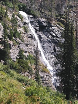
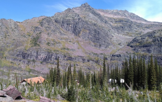
After following Sprague Creek for two miles the trail reaches an opening where you'll enjoy a great view of Beaver Medicine Falls, which plunges down a rock wall off to your right. Unfortunately the trail doesn’t approach the waterfall for an up-close view. In this same area, if you look above, roughly 2,000 feet or so below the top of the cliff face, you should be able to see Sperry Chalet for the first time. You'll enjoy even better views as you ascend the series of switchbacks above the falls.
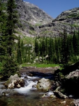
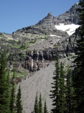
At roughly 5.75 miles hikers will arrive at a fork in the trail. Although there isn't a sign indicating which way to proceed, hikers should veer right and cross the footbridge over Sprague Creek to continue on towards Sperry Chalet. In this same vicinity you'll enter the outskirts of a beautiful sub-alpine meadow known as Glacier Basin. Look closely and you'll see at least five waterfalls cascading hundreds of feet down the cliff walls around you.
Roughly two-tenths of a mile later you'll reach another trail junction. The trail to the left leads to Comeau Pass and the Sperry Glacier observation point, roughly 3.8 miles away. To continue on towards the chalet you should turn right here. The chalet is only two-tenths of a mile from this junction.
At an elevation of more than 6550 feet, Sperry Chalet sits high atop a rock ledge that offers visitors commanding views of majestic mountain peaks, waterfalls, as well as Lake McDonald in the valley far below. You may also want to keep an eye out for the mountain goats that are often seen wandering around in this vicinity.
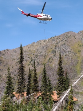
The two main buildings at Sperry consist of a two story dormitory and a kitchen/dining room. There's also a modern composting restroom facility located between these two buildings. As mentioned above, the historic stone dormitory was tragically lost during the Sprague Fire. On the afternoon of August 31st a hot ember from the valley below entered the structure near a second story window. Despite a dedicated group of firefighters on the site, specifically working to protect the chalet complex, the ember ignited the wooden portion of the structure and proceeded to burn the entire interior of the building. Fortunately, national park officials immediately made the decision to rebuild the chalet. In October of 2019, roughly two years after the fire was contained, reconstruction of the interior and the roof was completed. During our most recent hike to the chalet, in September of 2019, we had a birds-eye view of several helicopter runs as they transported and removed materials for workers as they prepared to put the finishing touches on the project.
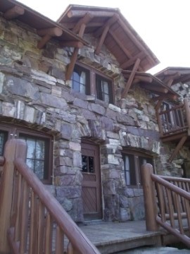
Now listed as an Historic Landmark, the Sperry Chalet dining chalet was built by the Great Northern Railway in 1913, while the dormitory was completed during the following year. For a more in-depth history of Glacier's historic hotels and backcountry chalet system, I highly recommend View with a Room. For more information on staying at Sperry, and to make a reservation, please click here.
For those visiting Sperry on a day hike you may want to note that the dining room is open to the public from 11:30 a.m. to 5:00 p.m. every day. They offer a lunch menu that includes soups, sandwiches and snacks. For dinner or breakfast, reservations are required, and can be made by calling the reservation office at 1-888-345-2649.
If your preference is to sleep under the stars, backpackers have a couple of options in the area. Near the Chalet is a backcountry campground with four individual campsites. Three miles further up trail, at Lake Ellen Wilson, is another campground containing four sites.
Both the chalet and glacier were named for Dr. Lyman B. Sperry of Oberlin College, who scouted for "scenic attractions" on behalf of the Great Northern Railway. Sperry was the leader of the first party to reach the glacier in 1895. He also oversaw the construction of the trail that provided access to the glacier from the Lake McDonald Lodge. Dr. Sperry's trail, constructed in 1902 and 1903 by college boys from Minnesota, was likely the first organized trail-building effort in the park. Sperry's motivation for building the trail came from his thought that by providing access to the most beautiful portions of Glacier's backcountry, more people would have the opportunity to see the wonders of the area, and thus increase the probability of preserving it as a national park. My book, Ramble On (a history of hiking), contains much more information on trail development in Glacier, as well as other anecdotal stories from the early years of the park.