Snyder Lake
| Trail Features: | Subalpine Lake, Scenic views | 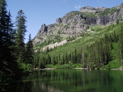 |
|||
| Trail Location: | Lake McDonald Lodge | ||||
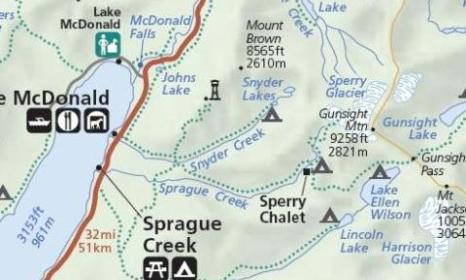
| Roundtrip Length: | 8.7 Miles | ||||
| Total Elevation Gain: | 2045 Feet | ||||
| Avg. Elev Gain / Mile: | 470 Feet | ||||
| Highest Elevation: | 5247 Feet | ||||
| Trail Difficulty Rating: | 12.79 (strenuous) | ||||
| Parking Lot Latitude | 48.61686 | ||||
| Parking Lot Longitude | -113.87554 | ||||
Trail Description:
The hike to Snyder Lake in Glacier National Park begins from the Sperry Trailhead, located across the road from the Lake McDonald Lodge. In a very short distance, after passing the horse path, the trail becomes known as the Gunsight Pass Trail.
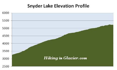
Almost immediately the trail begins climbing, passing through an old growth forest of red cedar, western larch and hemlock along the lower elevations, to a dense spruce-fir forest as it ascends higher. Many hikers and horses will be sharing this heavily used segment of the trail as they head up to Sperry Chalet and other destinations in the area.
At roughly three-quarters of a mile from the trailhead hikers will begin noticing a few burn spots from the Sprague Fire. The blaze was ignited on August 10, 2017 when lightning struck along the north side of Sprague Creek, roughly three miles from the Lake McDonald Lodge. During the two-month blaze the wildfire burned 16,982 acres, and destroyed the interior of the historic Sperry Chalet dormitory. Hikers should note that park crews have cleared thousands of trees that had fallen on trails throughout the burn area. As a result, some of these trails will have limited shade in some areas.
 Hikers will have already climbed more than 900 feet upon reaching the Mt. Brown Trail junction, located roughly 1.6 miles from the trailhead. Just one-tenth of a mile past this junction is the turn-off for the Snyder Lake Trail. After turning left at this junction hikers will generally continue to follow along Snyder Creek, which flows down the valley between Mt. Brown and Edwards Mountain. Much of the route to Snyder Lake passes through tall vegetation, so it's a very good idea to make a lot of noise and keep an eye out for bears as you proceed up the valley. Depending on your timing, you may also see a wide variety of wildflowers along this stretch of the trail as well.
After gaining another thousand feet over the course of the next 2.5 miles, the trail tops out at an elevation of nearly 5250 feet, before making a short descent down to the lake.
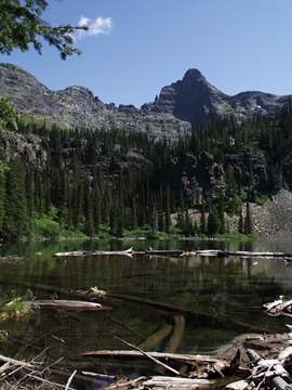
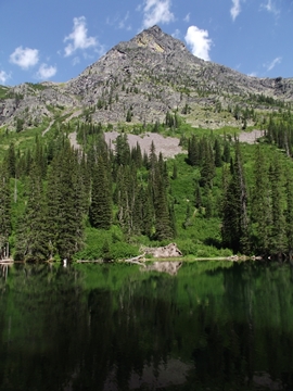
Snyder Lake lies in a basin surrounded by 8565-foot Mt. Brown towards the north, and Edwards Mountain towards the south. 7886-foot Little Matterhorn, towards the northeast, is the mountain that lies directly ahead of you as you arrive at the foot of the lake. If you look closely you'll notice a couple of waterfalls cascading down the cliff walls surrounding the lake.
Both the lake and creek are named after George Snyder, the man who built a framed, two-story hotel in 1895 at the present day site of the Lake McDonald Lodge. During that same year Snyder would build a road 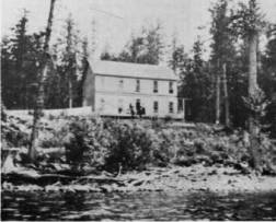 from the new railroad depot at Belton (now called West Glacier) to the small village of Apgar. The road would allow Snyder to transport the 40-foot steamboat that he had just purchased to Lake McDonald. The road would also allow visitors arriving by railroad to travel to Apgar, board his steamboat, and then sail the eight miles up the lake to stay at his hotel, known as the "Glacier Hotel". John Lewis gained ownership of the hotel around 1906, purportedly after winning it in a card game.
The official maintained trail ends at the western shore of Lower Snyder Lake. However, the adventurous can continue their hike by bushwhacking up a relatively steep slope alongside Snyder Creek to visit an unnamed waterfall, and beyond that, Upper Snyder Lake.