Siyeh Pass Loop
| Trail Features: | Outstanding views, Alpine meadows | 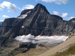 |
|||
| Trail Location: | Siyeh Bend | ||||
| Roundtrip Length: | 10.4 Miles | ||||
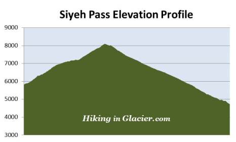
| Total Elevation Gain: | 2280 Feet | ||||
| Avg. Elev Gain / Mile: | 438 Feet | ||||
| Highest Elevation: | 8100 Feet | ||||
| Trail Difficulty Rating: | 14.96 (strenuous) | ||||
| Parking Lot Latitude | 48.70145 | ||||
| Parking Lot Longitude | -113.66959 | ||||
Trail Description:
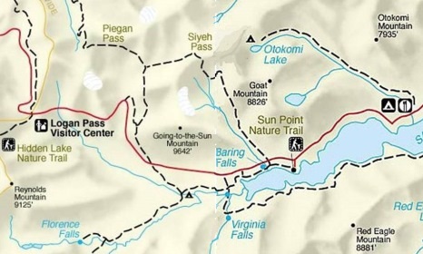
The Siyeh Pass Loop in Glacier National Park begins from the Siyeh Bend Trailhead, located 2.2 miles east of Logan Pass on the Going-To-The-Sun Road. Although called a loop hike, it's actually a one-way semi-circle that begins at Siyeh Bend and ends at Sunrift Gorge. Hikers also have the option of starting from the Piegan Pass Trailhead at the Jackson Glacier Overlook, but this would add a little more distance and several hundred more feet of climbing to your hike. The Siyeh Bend Trail offers hikers a much more gradual climb to the pass.
To complete this hike you'll either have to have two vehicles, or you'll have to take the shuttle before or after your hike. If you're a slow hiker it's probably best to leave your car at Sunrift Gorge, and then take the shuttle up to Siyeh Bend first thing in the morning. Otherwise, you may not be able to make it back to Sunrift Gorge early enough to catch the last shuttle heading back up to Siyeh Bend.
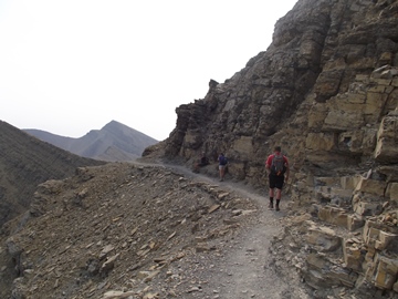
From the Going-To-The-Sun Road, the Siyeh Bend Trail travels alongside Siyeh Creek for roughly two hundred yards before making a sharp right turn into the forest. At roughly 1.1 miles from the trailhead hikers will arrive at the Piegan Pass Trail junction. A turn to the right leads down to the Jackson Glacier Overlook. To continue towards Siyeh Pass hikers should turn left here.
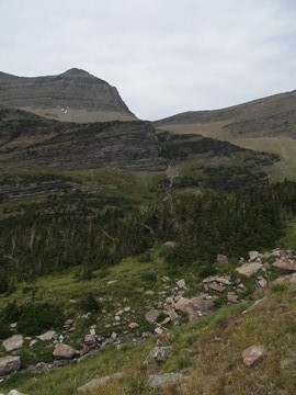
The lower elevations of the hike pass through a dense spruce-fir forest. The forest, however, begins to thin out as you approach the Siyeh Pass Trail junction, located almost 2.7 miles from the trailhead. To continue towards the pass you should turn right onto the Siyeh Pass Trail at this junction.
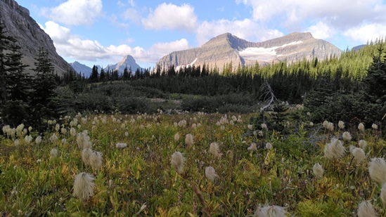
Roughly two-tenths of a mile beyond the junction hikers will enter Preston Park, a glacially-carved valley known for its incredibly beautiful meadows and abundant wildflowers. Preston Park is actually a series of high alpine meadows interspersed by stands of pine trees. The meadows become increasingly larger as you proceed further up the valley. If Siyeh Pass is impassable due to snow or bad weather, this would still be an excellent destination by itself.
From this point forward, over the course of the next seven miles, hikers will be completely exposed to all the elements. You should also note that bears are known to frequent the Preston Park area, so make sure you make a lot of noise, carry bear spray, and hike in groups.
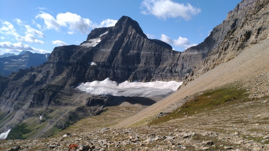
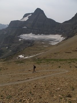
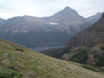
As you proceed up the trail you'll enjoy commanding views of 9365-foot Matahpi Peak towards the south. Piegan Mountain will dominate the view towards the west, while the pyramid-shaped Heavy Runner Mountain can be seen towards the southwest. Siyeh Pass becomes visible at this point as well. It sits on the saddle between Matahpi Peak on your right, and 10,014-foot Mt. Siyeh towards the north.
As if climbing the mountain wasn't enough of a thrill, a BASE jumper leapt off Mt. Siyeh in 1997, intending to land near Cracker Lake on the other side of the peak. Almost immediately after jumping the man hit a wall and his parachute became caught on a rock outcropping roughly 400 feet below the summit. A daring rescue involving eight rangers and several other park employees pulled the man to safety, who suffered only minor injuries.
At roughly 3.5 miles the trail crosses Siyeh Creek. Shortly thereafter you'll begin the final climb up to Siyeh Pass. Over the course of the next 1.25 miles hikers will ascend almost 900 feet along a series of switchbacks. This will be the toughest section of the entire hike.
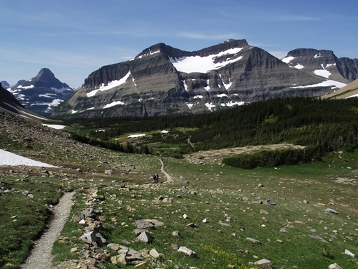
At almost 4.5 miles hikers will reach Siyeh Pass. From this vantage point, atop of the saddle between Matahpi Peak and Mt. Siyeh, you'll be standing above a large snowfield that lies along the east side of the pass. Hikers will also have commanding views of the Boulder Creek drainage towards the northeast, as well as 8826-foot Goat Mountain, which dominates the landscape towards the east.
From this vantage point the trail continues to climb along a series of steep switchbacks, and gains another 200 feet over the course of the next three-tenths of a mile before reaching the highest point on the trail. Topping out at 8100 feet, this is one the highest maintained trails in the park.
Both Mt. Siyeh and Siyeh Pass were named by George Bird Grinnell for a Blackfoot Indian by the name of "Sai-yeh," which in the Blackfeet language means Crazy Dog, or Mad Wolf.
 Siyeh Pass also has the distinction of being one of four sites in Glacier to have had a locomotive bell installed on it. In 1925, W. R. Mills, an advertising agent with the Great Northern Railway, and H. A. Noble, manager of the Glacier Park Hotel Company, requested permission from the park to place locomotive bells on the summits of several passes in Glacier. According to Donald H. Robinson's Administrative History of Glacier National Park, the request was based on the old Swiss custom of placing bells on mountain tops and passes in order to allow hikers and horseback riders the unusual experience of ringing loud bells in the mountains, and to let people in the valleys know that they had reached their destination.
In September of 1926 the request was finally granted to place bells at Swiftcurrent, Piegan and Siyeh passes. Three years later a fourth bell was added at Scenic Point in Two Medicine. The bells remained in place until the fall of 1943 when they were removed by the Hotel Company and donated to a World War II scrap metal drive. My book, Ramble On (a history of hiking), includes information on trail development in Glacier, as well as many other hiking related stories from the early years of the park.
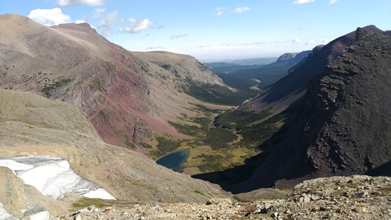
Once you arrive at the top of the pass the trail will traverse across a small ledge along the northeastern slopes of Matahpi Peak. Here you’ll enjoy commanding views of the Boulder Creek valley. As you continue, spectacular views of the Baring Creek valley will begin to emerge. After passing across this short section you'll notice a huge cairn marking the pass. If you continue on for another 50 feet or so you’ll find a great spot for an extended break where you can soak-in the absolutely stunning scenery.
From this perch 9642-foot Going-to-the-Sun Mountain will dominate the view to your right. Just below the top of the mountain is Sexton Glacier. Immediately to your left is 8826-foot Goat Mountain, and across the valley in the far off distance are Red Eagle Mountain, Mahtotopa Mountain and Little Chief Mountain. You'll even be able to see a small sliver of St. Mary Lake in the valley far below.
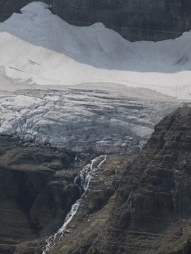
From the top of the pass the trail descends fairly rapidly along a series of switchbacks. Although at times it seems as if the trail might be heading over towards Sexton Glacier, it never really gets close to the 68-acre glacier. However, as you descend, the views of the glacier will become progressively more dramatic. The southern portions of Sexton Glacier are especially interesting as you can see the huge crevasses that would make exploring it virtually impossible. Hikers will also be treated to a couple of waterfalls that plunge more than a thousand feet off the glacier. In effect, these are the headwaters of Baring Creek.
As you descend be sure to make note of the rocks along the trail and along the headwall. There’s literally a riot of colors represented in this canyon, including red, aqua green, yellow and purple.
The descent from the pass is long and steep. Over a seemingly endless series of switchbacks the trail drops almost 1450 feet in roughly 2.5 miles. At roughly 7.3 miles from the trailhead this section of switchbacks finally comes to an end, at which point the terrain moderates substantially. Just beyond the last switchback you'll begin passing through a fairly long stretch of huckleberries. Baring Creek will still be more than 700 feet below you at this point.
After a long straight stretch the trail comes to another switchback at roughly 8.8 miles. This is a great place for a quick stop to soak-in the views of St. Mary Lake in the valley below. The mountain dominating the view across the lake is 9541-foot Little Chief Mountain (see photo above). From here the trail descends a few more switchbacks, and shortly thereafter enters a forest of stunted trees, also known as krummholz.
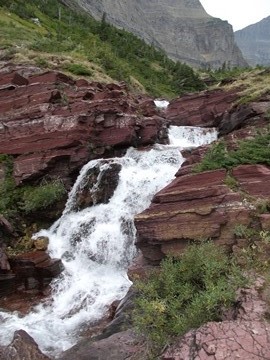
At just under 9.3 miles the trail finally reaches Baring Creek where you'll find a pretty impressive waterfall. The stream continues to cascade down a beautiful red rock gorge with several other smaller waterfalls along the way.
At roughly 10.4 miles the trail ends at Sunrift Gorge, a steep, narrow canyon where Baring Creek cuts through a natural break in the rock. Hikers will enjoy a nice view of the gorge just before exiting the trail at the Going-to-the-Sun Road. In all, the Siyeh Pass Loop offers a wide variety of scenery as it passes through several life zones, easily making this one of the best hikes in Glacier National Park.