Scenic Point
| Trail Features: | Outstanding views, Alpine tundra | 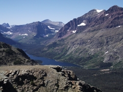 |
|||
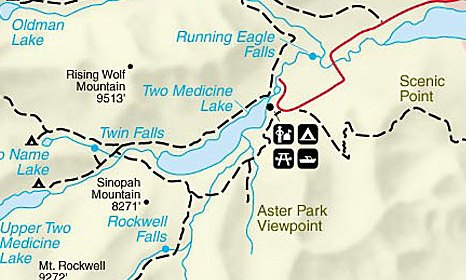
| Trail Location: | Two Medicine (Scenic Point Trailhead) | ||||
| Roundtrip Length: | 8.0 Miles | ||||
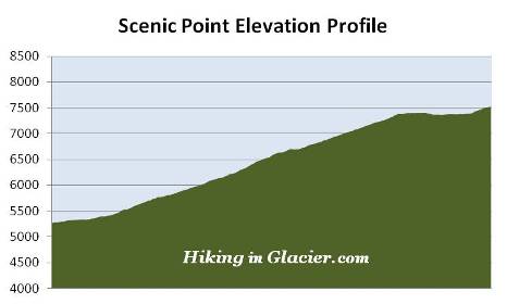
| Total Elevation Gain: | 2300 Feet | ||||
| Avg. Elev Gain / Mile: | 575 Feet | ||||
| Highest Elevation: | 7522 Feet | ||||
| Trail Difficulty Rating: | 12.60 (strenuous) | ||||
| Parking Lot Latitude | 48.4852 | ||||
| Parking Lot Longitude | -113.36146 | ||||
Trail Description:
The hike to Scenic Point in Glacier National Park begins from the Scenic Point parking area, located 2.7 miles west of the Two Medicine entrance station. Although it's a fairly large lot, parking can sometimes be an issue, especially if there's a ranger-led hike scheduled for Scenic Point that day.
To reach your destination you'll be following the Mt. Henry Trail for most of your hike. The trail owes its existence to the Great Northern Railway. In order to make transportation easier between their two properties, the Glacier Park Lodge and the Two Medicine Chalets, the railroad company contracted to have the trail built in 1913.
The Mt. Henry Trail also serves as a segment of the Continental Divide Trail, which runs from the Mexican border in New Mexico, all the way to the town of Waterton Park in Canada.
At roughly six-tenths of a mile from the trailhead hikers will reach the short side trail that leads to Appistoki Falls. If you wish to make a quick visit to see the falls, the viewpoint is only a hundred yards or so from the junction.
 Just above the falls hikers will emerge above the treeline, and for the most part will remain in the open all the way to Scenic Point. The trail also begins to climb in earnest. From this point forward there are roughly 16 switchbacks that hikers will have to ascend before reaching their destination.
Over the next couple of miles, as you proceed higher, hikers will enjoy outstanding views of the Appistoki valley, and the Appistoki basin, which lies between 8164-foot Appistoki Peak towards the west and 8847-foot Mt. Henry to the south.
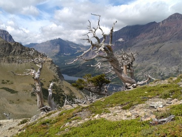
Roughly one mile from the trailhead hikers will enter a ghost forest of dead whitebark pines, the result of white pine blister rust, a fungal disease that was accidentally introduced from Europe around 1900. According to a park brochure nearly half of the original whitebark pine population in Glacier is already dead. It's estimated that more than 75% of the remaining trees are already infected with the disease, and will die within the next 20 years.
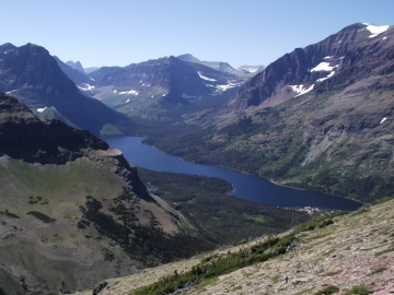 The views of Two Medicine Lake improve dramatically as you climb higher. If you're looking to take a great photo of the lake, the view from the trail is actually much better than the view from Scenic Point. Moreover, it's likely you'll go home with a better picture if taken in the morning, on your way up, rather than later, on your return.
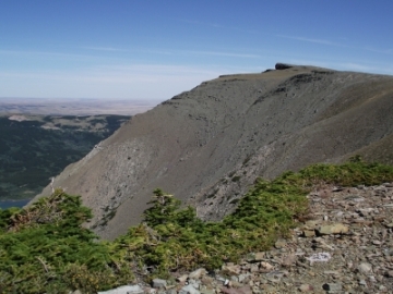
At 3.1 miles you'll ascend a saddle, and will have your first views of Scenic Point towards the northeast. If you follow around the rim of the bowl you'll see the rock ledge as it juts out towards the north (see photo below).
Climbing a short distance above the saddle will complete most of the elevation gain on this hike. From here the path tracks along a fairly narrow ledge as it traverses around the top of the bowl. Although the drop-offs are rather steep, they're not quite as sheer as the drop-offs you'll find on the Highline Trail. For early season hikers, however, you should note that snow can linger in this area well into the summer in some years. Also, the area around the bowl, as well as the route up to Scenic Point, can be quite windy at times. You may want to consider bringing trekking poles to help with balance.
Once on the other side of the bowl the trail continues by cutting across alpine tundra that offers sweeping views of the surrounding terrain. At roughly 3.9 miles you'll finally reach the short side trail that leads to Scenic Point. From this junction the Mt. Henry Trail continues to the town of East Glacier Park. Hikers should turn left here to make the short trek up to Scenic Point. Though short, you’ll make a pretty steep climb of roughly 145 feet over the course of the next 0.15 miles to reach the overlook.
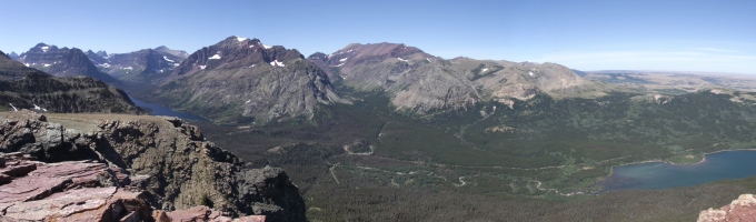
From the top of Scenic Point the panoramic views are simply stunning. Hikers will be able to see almost the entire Two Medicine Valley, including Lower Two Medicine Lake, Two Medicine Lake and even Upper Two Medicine Lake. Looking south you can see the town of East Glacier Park, the Lewis and Clark National Forest, and as far away as the Bob Marshall Wilderness Area. Looking towards the east you'll be able to see the town of Browning, as well as the Sweet Grass Hills rising above the Great Plains roughly 90 miles away!
Scenic Point has the distinction of being one of four sites in Glacier to have had a locomotive bell installed on it. In 1925, W. R. Mills, an advertising agent with the Great Northern Railway, and H. A. 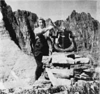 Noble, manager of the Glacier Park Hotel Company, requested permission from the park to place locomotive bells on the summits of several passes in Glacier. According to Donald H. Robinson's Administrative History of Glacier National Park, the request was based on the old Swiss custom of placing bells on mountain tops and passes in order to allow hikers and horseback riders the unusual experience of ringing loud bells high in the mountains, as well as to let people in the valleys know that they had reached their destination.
In September of 1926 the request was finally granted to place bells at Swiftcurrent Pass, Piegan Pass and Siyeh Pass. Three years later a fourth locomotive bell was added atop Scenic Point. The bells remained in place until the fall of 1943, at which point they were removed by the Glacier Park Hotel Company and donated to a World War II scrap metal drive. Ramble On: A History of Hiking discusses the fascinating story of why Glacier came to be associated with Swiss culture, and how it impacted the development of its extensive trail system during the early years of the park.