
St. Mary Area Waterfalls Hike
| Trail Features: | Waterfalls, Lake views | 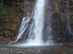 |
|||
| Trail Location: | St. Mary Falls Shuttle Stop | ||||
| Roundtrip Length: | 5.2 Miles | ||||
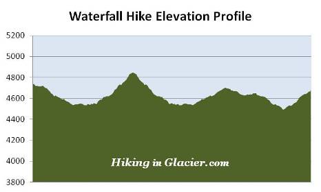
| Total Elevation Gain: | 700 Feet | ||||
| Avg. Elev Gain / Mile: | 269 Feet | ||||
| Highest Elevation: | 4845 Feet | ||||
| Trail Difficulty Rating: | 6.60 (moderate) | ||||
| Parking Lot Latitude | 48.6746 | ||||
| Parking Lot Longitude | -113.60807 | ||||
Trail Description:
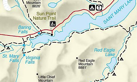
The St. Mary Area Waterfalls hike, which visits three named and two unnamed waterfalls, begins from the St. Mary Falls Shuttle Stop, located 10.6 miles west of the St. Mary Entrance Station on the Going-To-The-Sun Road. This hike ends at Sunrift Gorge, and assumes you'll be using the park's free shuttle system for transportation along the Going-To-The-Sun Road.
From the shuttle stop you'll begin your hike on the St. Mary Falls Cutoff Trail. For a brief segment near the beginning of the trail you'll enjoy commanding views of 8064-foot Dusty Star Mountain as it towers directly in front of you. Looking towards the south will be 8922-foot Almost-a-Dog Mountain and 9541-foot Little Chief Mountain. And if you look towards the west you’ll be able to see Fusillade, Reynolds and Heavy Runner Mountains.
As you descend towards St. Mary Falls you'll begin passing through an area that was burned during the Reynolds Creek Fire of 2015. At roughly one-quarter of a mile from the shuttle stop hikers will arrive at the Piegan Pass Trail junction. You should turn right here, and then proceed for a very short distance to reach another junction. The Piegan Pass Trail continues up the hill towards the right. To continue on towards St. Mary Falls hikers should veer left onto the St. Mary Lake Trail at this juncture.
 At roughly six-tenths of a mile hikers will reach the St. Mary River. Soon afterwards you'll begin hearing the thunder of crashing water, and in another quarter-mile, will arrive at St. Mary Falls, one of the more spectacular waterfalls in Glacier National Park.
St. Mary Falls drops roughly 35 feet in three separate tiers, with the two largest being the most photogenic. A smaller waterfall can be found below the footbridge. Even on a hot August day the rush of water forces a cool breeze down the narrow gorge. You'll also likely notice the incredibly beautiful aqua-green color of the pools just below the falls.
Keep an eye out for American dippers, also known as water ouzels, bobbing, or "dipping", along the rocks around the waterfalls, or diving under the water in search of food. Once below the surface of the water the dippers forage by either walking along the stream bottom, or by "flying" through the water, while using their wings to propel themselves through the swift currents. These small, slate-grey colored birds are also known to nest in this area.
Shortly after passing St. Mary Falls the trail begins to ascend along the west side of Virginia Creek. Before reaching Virginia Falls hikers will pass two series of cascades and waterfalls, both of which would be notable destinations in and of themselves. However, being located between two absolutely spectacular waterfalls, the relative aesthetic quality of the two unnamed falls may be somewhat diminished. That being said, however, they're still well worth a stop.
At 1.2 miles hikers will reach the first unnamed falls, a quite impressive cascade that drops in a series of four separate tiers. A quarter-of-a-mile up the trail is the second series of cascades and falls. Again these are quite impressive and well worth a visit.
 At 1.7 miles hikers will arrive at the Virginia Falls Viewpoint Trail junction. Staying towards the left continues along the St. Mary Lake Trail. To visit Virginia Falls hikers should veer to the right here. The base of the upper falls is less than a tenth-of-a-mile from this junction.
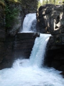
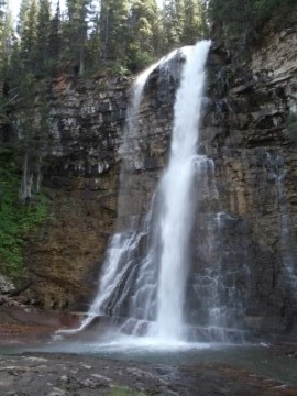
Virginia Falls is another multi-tiered waterfall, with the main fall dropping roughly 50 feet, another secondary chute, and then a short cascade section at the bottom. Stepping up to the base of the main falls and feeling the spray and the blast of cool air is like instant air conditioning, even on a hot August day. You may want to note that the rocks around the falls are quite slick.
Having hiked this several times now, I would probably have to rate Virginia Falls as the best waterfall hike in Glacier National Park. That's just my humble opinion, though.
To continue on towards your next destination, Baring Falls, requires hikers to backtrack all the way to the St. Mary Falls Cutoff Trail / Piegan Pass Trail junction. Up to this point you will have hiked roughly 3.4 miles. Although the sign at the junction doesn't indicate that Baring Falls is in this direction (it only indicates Sun Point), you'll have to make a right turn at this juncture. Baring Falls will arrive long before ever reaching Sun Point.
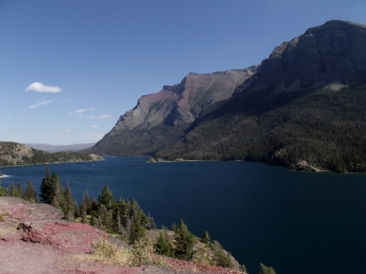
This next section of trail more or less follows the Going-To-The-Sun Road. You may even hear a truck or motorcycle for a very brief portion. Along this stretch hikers will enjoy sporadic views of Saint Mary Lake and the surrounding mountains.
At roughly 4 miles hikers will reach the Gunsight Horse Trail Cutoff, which leads up to the St. Mary Falls Trailhead, located just east of the shuttle stop.
A quarter-mile past this junction hikers will reach a vantage point that provides sweeping panoramic views of Saint Mary Lake. This perch sits roughly 100 feet above the lake, and is an outstanding spot for a lunch break, or to simply take a long pause to soak-in the incredibly beautiful scenery.
 From the overlook the trail continues to descend towards the lake. At 4.7 miles you'll reach a small boat dock along the shore of Saint Mary Lake. Baring Falls is now only a little more than a hundred yards away.
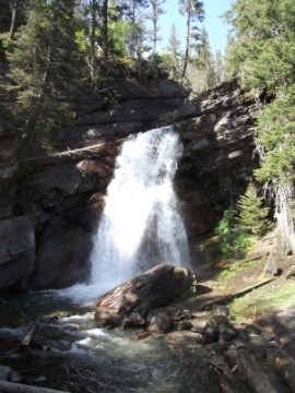
Baring Falls is a pleasant waterfall that drops roughly 25 feet over a rock ledge. After plunging over the ledge, Baring Creek continues flowing for another hundred yards or so before spilling into Saint Mary Lake. The area around the falls is another great place to look for water ouzels.
After viewing the waterfall hikers will almost immediately cross the footbridge spanning Baring Creek, and shortly thereafter, at roughly 4.9 miles, will reach the Siyeh Pass Trail junction. To continue on towards the Sunrift Gorge Shuttle Stop, hikers should turn left onto the Siyeh Pass Trail. A turn towards the right leads to Sun Point along the Sun Point Nature Trail.
At roughly 5.2 miles hikers will reach the Sunrift Gorge area on the Going-To-The-Sun Road. To return back to your car you'll have to hop on the park shuttle here. If you parked at Sun Point, you could return there by hiking back on the Sun Point Nature Trail. This option will add roughly four-tenths of a mile to your overall mileage.