Rocky Point Nature Trail
| Trail Features: | Lake, Scenic views | 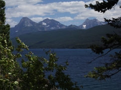 |
|||
| Trail Location: | Fish Creek Campground | ||||
| Roundtrip Length: | 1.9 Miles | ||||
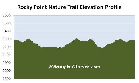
| Total Elevation Gain: | 350 Feet | ||||
| Avg. Elev Gain / Mile: | 368 Feet | ||||
| Highest Elevation: | 3309 Feet | ||||
| Trail Difficulty Rating: | 2.60 (easy) | ||||
| Parking Lot Latitude | 48.55262 | ||||
| Parking Lot Longitude | -113.98893 | ||||
Trail Description:
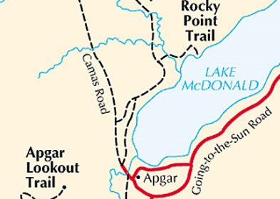
The hike to Rocky Point on the western shore of Lake McDonald in Glacier National Park begins from the North Fork Road near the Fish Creek Campground. To reach the trailhead from the Going-To-The-Sun Road near Apgar, drive 1.2 miles north on Camas Road. Turn right onto Fish Creek Campground Road and drive another 1.1 miles to the Fish Creek Campground. From here turn left onto the North Fork Road, which is a gravel road, and drive 0.4 miles to the parking area for the Rocky Point Trail on the left side of the road. The Rocky Point Trailhead is located across the road from the parking area.
Shortly after starting down the path hikers will cross over Fern Creek, and in a short distance, will reach a fork in the trail. The right fork leads to the Fish Creek Campground. Hikers should veer towards the left to continue on towards Rocky Point.
At just over a half-mile from the trailhead you'll arrive at another trail branching in from the Fish Creek Campground. Hikers should proceed straight ahead at this junction.
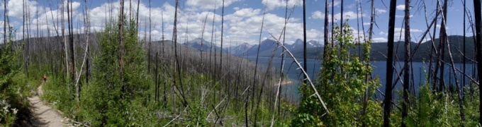
For most of its length the Rocky Point Trail passes through the ravages of the massive Robert Fire that scorched almost 40,000 acres along the shores of Lake McDonald in 2003. The fire was so intense that flames reached a height of 500 feet along Howe Ridge, just to the north of the trail. 2003 marked the fifth year of a five-year drought, and became one of the worst fire seasons in Glacier National Park history. That summer more than 136,000 acres burned in Glacier. That represents 13% of the park!
At six-tenths of a mile you'll reach the loop portion of the hike, which is known as the Rocky Point Nature Trail. The following description assumes you'll be hiking the loop in a counter-clockwise direction, which means we'll be taking a right at this junction.
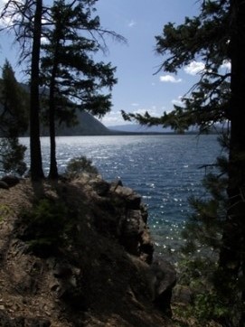
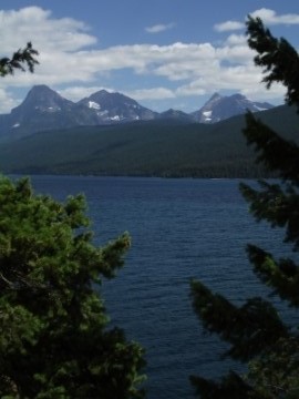
A short distance after turning onto the loop you'll notice a side trail branching off towards the lake. You'll definitely want to follow this short trail as it leads down to the shore along the west side of Rocky Point. The area around Rocky Point provides stunning views of Lake McDonald, as well as the mountains towards the northeast in the Sperry Glacier vicinity.
After soaking in the magnificent scenery at Rocky Point you can easily pick up the main trail on the far end of this side trip.
As you proceed along the northern portion of the loop you’ll begin to see a massive amount of destruction from the forest fire. There will be thousands of dead trees standing like tooth picks in this area. The forest, however, is already in the process of regeneration. You'll see Douglas fir, lodgepole pine, western larch and ponderosa pine already growing in soils that have been enriched with nutrients from ash. Most of these young saplings are already 4-6 feet in height at this point.
At 1.2 miles hikers will reach the Lake McDonald Trail junction. To continue on the loop hike you should turn left here.
Two-tenths of a mile further down the trail you'll exit the loop portion of this hike, and will begin your return trip back to the trailhead on the North Fork Road.