Redrock Falls
| Trail Features: | Waterfalls, Lakes, Scenic views | 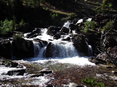 |
|||
| Trail Location: | Swiftcurrent Pass Trailhead | ||||
| Roundtrip Length: | 4.2 Miles | ||||
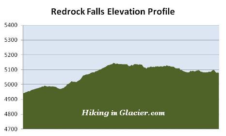
| Total Elevation Gain: | 285 Feet | ||||
| Avg. Elev Gain / Mile: | 136 Feet | ||||
| Highest Elevation: | 5145 Feet | ||||
| Trail Difficulty Rating: | 4.77 (easy) | ||||
| Parking Lot Latitude | 48.79763 | ||||
| Parking Lot Longitude | -113.67854 | ||||
Trail Description:
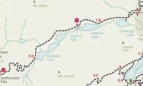
The hike to Redrock Falls in Glacier National Park begins from the Swiftcurrent Pass Trailhead in Many Glacier. The trailhead is located at the far end of the parking area for the Swiftcurrent Motor Inn at the end of Many Glacier Road.
A short distance beyond the normally busy parking lot the trail crosses over Wilbur Creek. After walking roughly one-third of a mile hikers will reach the side path that leads to Fishercap Lake, the first destination on this hike. From this junction it's a very short walk of less than a hundred yards to reach its northern shore. Although some might bypass this gem, it's well worth the trip, as the views of the lake and the surrounding mountains are quite stunning. A pleasant beach area makes this a great spot for a picnic, or even a short hike for those who have small kids. Fishercap Lake is also a great place to spot a moose, especially in the mornings and early evenings. The lake's name is a reference to George Bird Grinnell, whom the Blackfeet Indians called "Fishercap".
At roughly eight-tenths of a mile the trail begins passing through a long stretch of aspens growing alongside the path, making this an excellent choice for a fall hike when their leaves turn golden yellow and orange.
For the most part the trail travels under the canopy of the forest as it makes its way towards Redrock Falls, however, there are several open areas along the way that provide outstanding views of the surrounding mountains. You'll also pass through several patches of thimbleberries and huckleberries that can make for some tasty snacks when in season. Although this is a very popular trail, hikers should still make plenty of noise to warn any bears that might be around that you're passing through their territory.
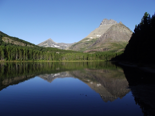
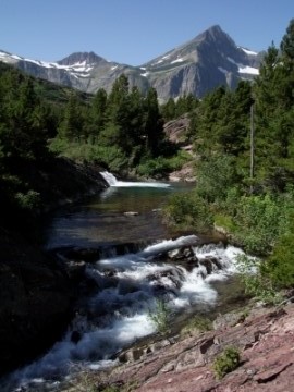
At 1.7 miles hikers will reach Redrock Lake, the second destination on this hike. The views from this lake are also quite beautiful. Here you'll enjoy commanding views of 8851-foot Mt. Grinnell and Swiftcurrent Glacier towards the southwest, and 8436-foot Swiftcurrent Mountain almost directly towards the west. If you look closely you may be able to spot the fire tower atop Swiftcurrent Mountain. On the opposite side of the lake, lying below Mount Grinnell, is Redrock Falls.
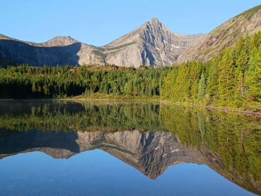
From this point the trail proceeds along the northern shore of the lake. As you make your way around to the far western shore you'll pass some of the red rock formations that provided the inspiration for the naming of the nearby lake and falls.
At just over 2 miles hikers will reach an unmarked split in the trail. Walking a short distance along the left fork will lead you down to the lower falls.
Redrock Falls is actually a series of cascades, and in my opinion, one of the more picturesque waterfalls in Glacier National Park. Upon arrival at the lower falls you'll notice several short side trails, or social trails, that lead to various vantage points that offer views of the lower and upper falls. It's well worth the effort to do a little scrambling if you're looking for some great photographic opportunities.
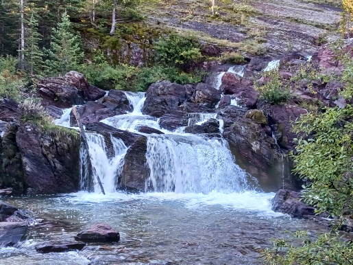
After returning back to the main trail you'll have the option of continuing up the trail for a short distance to view the highest falls in the series. Swiftcurrent Mountain will provide the backdrop for a picture-perfect scene here.
The hike to Redrock Falls is an outstanding hike. Since it's relatively short and relatively flat, this is an excellent choice for the entire family. If you still have the energy and wish to explore more of the terrain in this area of the park, you can continue your hike to visit Bullhead Lake further up the valley. This would add another 3 miles and only a hundred feet of climbing to your overall hike.