Ptarmigan Lake
| Trail Features: | Outstanding views, Alpine Lake | 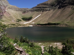 |
|||
| Trail Location: | Iceberg Lake Trailhead | ||||
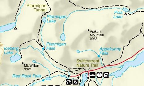
| Roundtrip Length: | 8.8 Miles | ||||
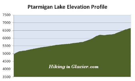
| Total Elevation Gain: | 1700 Feet | ||||
| Avg. Elev Gain / Mile: | 386 Feet | ||||
| Highest Elevation: | 6651 Feet | ||||
| Trail Difficulty Rating: | 12.20 (strenuous) | ||||
| Parking Lot Latitude | 48.79958 | ||||
| Parking Lot Longitude | -113.67924 | ||||
Trail Description:
The hike to Ptarmigan Lake in Glacier National Park begins behind the cabins near the Swiftcurrent Motor Inn. There's enough parking for roughly 12-15 cars in the lot next to the trailhead. However, given the popularity of the area, it's likely the lot will be full, in which case you’ll have to park in front of the Swiftcurrent Motor Inn. This will add another two-tenths of a mile walk to reach the trailhead.
 Just beyond the Iceberg Lake Trailhead hikers will immediately turn right at a junction to access the short connector trail that leads to the Ptarmigan Trail. This connector trail makes a fairly steep climb, gaining roughly 185 feet in only a quarter-of-a-mile. However, once on the Ptarmigan Trail, the grade becomes much more moderate.
Upon reaching the Ptarmigan Trail junction hikers should turn left. A turn to the right will lead you down to the Many Glacier Hotel.
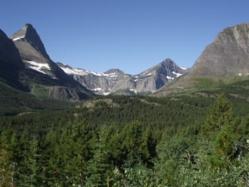
Along the upper reaches of the connector trail, as well as on the early sections of the Ptarmigan Trail, hikers will enjoy commanding views of 8851-foot Mt. Grinnell and 8436-foot Swiftcurrent Mountain towards the southwest. The dominating feature towards the west is 9321-foot Mt. Wilbur, and lying towards the northwest, in the direction you're heading, is the Ptarmigan Wall.
The Many Glacier area, especially along the Ptarmigan Trail corridor, is located in prime bear habitat. The first mile or so past the connector is a haven for grizzly bears. Nearly every time that I've hiked this trail I've spotted at least one along the hillside. It's extremely important for hikers to make a lot of noise, carry bear spray, and hike in groups in this area. As a result of its location, trails in the Many Glacier area are frequently closed due to bear activity. Thus, it's always a good idea to check with a ranger on the status of a trail before proceeding on any hike in Glacier National Park.
The first segment of the hike passes through open terrain that offers grand views of the surrounding mountains. However, as you proceed further along, the trail enters a fairly dense pine forest roughly 1.5 miles from the trailhead.
At 2.5 miles hikers will reach a small clearing overlooking Ptarmigan Falls. Unfortunately this will be the best view of the falls you'll have, as steep terrain makes it virtually impossible to get a closer look. Moreover, tree cover blocks a full view of the falls from top to bottom.
Just above Ptarmigan Falls is an open and rocky area that's become a popular spot for a quick snack break or an extended rest stop. Shortly after passing the falls you'll cross a footbridge over Ptarmigan Creek. Roughly a tenth-of-a-mile later you'll reach the Iceberg Lake Trail junction, which takes hikers to one of the most beautiful alpine lakes in the park. Turning right and continuing on the Ptarmigan Trail will lead hikers to Ptarmigan Lake. With most people heading towards Iceberg Lake, this segment of the trail won't be nearly as heavily traveled as the first section.
Beyond the junction hikers will begin another fairly steep climb of more than 400 feet over the next six-tenths of a mile. This section also passes through a thick patch of huckleberries. This is another place where you'll need to make a lot of noise in order to avoid a surprise encounter with a bear.
Once this relatively short ascent is completed, the saddle above the Ptarmigan Tunnel will be directly ahead of you. Shortly thereafter you'll emerge above the treeline where views of the Ptarmigan Wall become even more dramatic. The Ptarmigan Wall, towering more than 1700 feet above the trail at this point, is an arête, which is defined as a thin ridge of rock separating two valleys that have been carved by glaciers. In this case, the Ptarmigan Wall separates the Many Glacier valley from the Belly River valley.
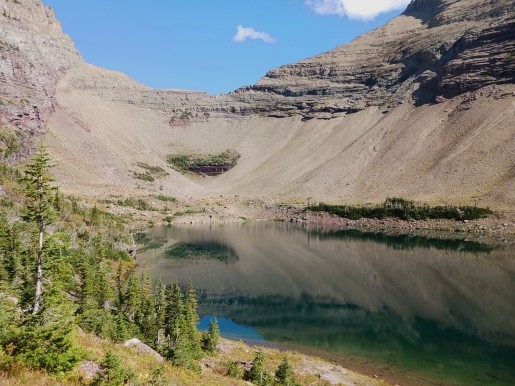
Roughly 4.2 miles from the trailhead hikers will reach a series of waterfalls and cascades tumbling down Ptarmigan Creek in the valley below the trail. Just beyond this point is Ptarmigan Lake. Although the main trail continues above the shore, there's a short side trail that drops down to the foot of the lake.
Framing the glacially carved lake is the Ptarmigan Wall towards the west, and 8914-foot Crowfeet Mountain towards the east. In between, to the north, is the saddle above Ptarmigan Tunnel. You may also want to keep an eye for bighorn sheep and mountain goats, as they are frequently seen in the area surrounding the lake.
For those who still have the energy at this point, you'll have the option of making the one-mile hike, and 600-foot ascent up to Ptarmigan Tunnel.