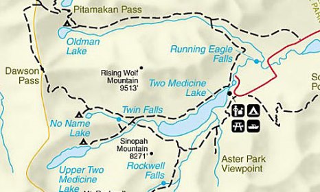
Pitamakan Pass
| Trail Features: | Outstanding views, Lake views | 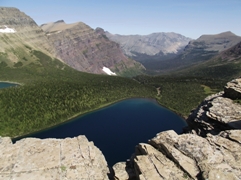 |
|||
| Trail Location: | Two Medicine Campground | ||||
| Roundtrip Length: | 15.4 Miles | ||||
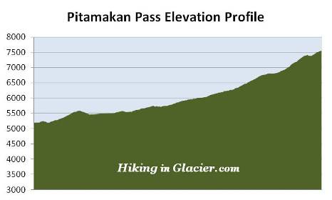
| Total Elevation Gain: | 2500 Feet | ||||
| Avg. Elev Gain / Mile: | 325 Feet | ||||
| Highest Elevation: | 7549 Feet | ||||
| Trail Difficulty Rating: | 20.40 (strenuous) | ||||
| Parking Lot Latitude | 48.49212 | ||||
| Parking Lot Longitude | -113.36561 | ||||
Trail Description:
The hike to Pitamakan Pass in Glacier National Park begins from the North Shore Trailhead, located in the campground at Two Medicine. To reach the trailhead from Two Medicine Road, turn into the campground and drive a half-mile along the main road. The parking area for the trail will be on your left. If this lot is full there's another small parking area located a short distance before reaching the main lot.
From the trailhead hikers will immediately cross a footbridge over the Pray Lake outlet stream. After walking another tenth-of-a-mile you’ll reach the Dawson Pass Trail junction. The path to the left leads to Dawson Pass, while the Pitamakan Pass Trail leads to the right.
After circling around the Two Medicine Campground, the Pitamakan Pass Trail begins to skirt along the eastern slopes of Rising Wolf Mountain.
 Roughly 2.3 miles from the trailhead hikers will cross a footbridge over Dry Fork Creek. After walking another two-tenths of a mile you'll arrive at the Dry Fork Trail junction. A turn to the right will lead you down to the Two Medicine Entrance Station. To continue towards Pitamakan Pass you should turn left here. At this point you'll be on the north side of Rising Wolf Mountain where the trail begins a westerly course through a broad valley. Over the next two miles hikers will travel across relatively flat terrain. Throughout this section the footpath alternates between large open meadows, mixed pine forests, and a couple of small aspen groves.
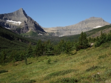
At 4.2 miles the trail begins traveling through a large open meadow. From here you'll enjoy commanding views of the surrounding mountains, including Flinsch Peak and Mt. Morgan as you look towards your destination almost directly straight ahead.
At roughly 6.3 miles hikers will reach the side trail to Oldman Lake. Just before arriving at this junction you'll pass through a long stretch of huckleberries, which just might be one of the thickest patches you'll find in the entire park. Also, as you near the junction, you'll have your first up-close views of Pitamakan Pass, which is the low point atop the ridge on your right. For those considering a backpacking trip there's a campground at Oldman Lake with four individual campsites.
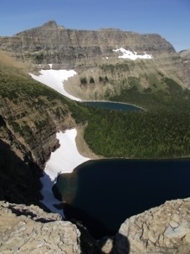 After walking roughly a quarter-mile past the junction you'll reach the base of the climb to the top of the pass. From here the trail ascends 750 feet over the course of the next 1.1 miles. As you proceed higher views of Oldman Lake will continue to improve. At the end of a very long switchback you’ll enjoy commanding views of Rising Wolf Mountain and Boy Lake. Much further down the valley, beyond the v-shaped canyon, you'll also be able to see Lower Two Medicine Lake. Young Man Lake, however, is hidden by a flank on Flinsch Peak.
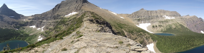
Beyond this switchback hikers will traverse a section of trail that has a little bit of exposure as it passes over a fairly narrow ledge. This area is known for high winds, so you may want to consider bringing trekking poles to help with balance. If high winds are present, and conditions appear to be too dangerous, you may want to consider turning around at this point.
At 7.7 miles hikers will finally reach the top of the pass. The views are simply stunning here. The pass lies at the top of a knife-edge ridge. The width of this narrow saddle is roughly 20-25 feet, so you'll have commanding views of the valleys on either side of the pass. Many people say that Dawson Pass has the better views. I would have to respectfully disagree with them.
Directly below the south side of the pass is Oldman Lake, which lies in the basin below Flinsch Peak. On the far side of Flinsch Peak is Dawson Pass. Looking towards the west is 8781-foot Mt. Morgan. A little further north of Mt. Morgan is 8285-foot McClintock Peak, with the Lake of the Seven Winds sitting in the basin just below it. The large lake directly below you, towards the north, is Pitamakan Lake, while the lake in the far off distance is Morning Star Lake. In between, but hidden from view by a ridge, is Katoya Lake. The three mountains towards the northeast, starting counter-clockwise, are Red Mountain, Eagle Plume and Bad Marriage Mountain. The photo below looks due west, with Mt. Morgan in the center:
Hikers will have the option of continuing their hike to Dawson Pass, and then travel down to Two Medicine Lake to create an epic 15.7-mile loop, provided you catch the shuttle boat and have transportation back to the campground. If you don’t have transportation between the two trailheads you’ll have to add another 0.7 miles to your overall mileage. Another option is to take the Dawson Pass Trail all the way back to the campground. The total roundtrip mileage for this route is roughly 17.6 miles.
From the pass you can see the trail as it continues along the northern slopes of Mt. Morgan. From there it climbs over the Continental Divide and circles around Mt. Morgan, and then proceeds along the west slopes of Flinsch Peak before reaching Dawson Pass. To the west and north of Pitamakan Pass you'll also be able to see the Pitamakan Pass Trail as it makes its way down the mountain. It then passes between Lake of the Seven Winds and Pitamakan Lake, before heading towards its ultimate destination at Cut Bank.
The pass is named for a female warrior leader of the Blackfeet Nation from the early 1700s who experienced a vision quest near this area. Pitamakan led war parties on many highly successful raids, and was the only woman in the Blackfeet tribe ever to do so, or to be given a man's name. The English translation of her name is Running Eagle.