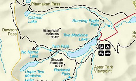
Oldman Lake
| Trail Features: | Alpine Lake, Outstanding views | 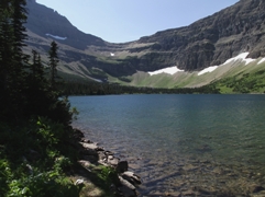 |
|||
| Trail Location: | Two Medicine Campground | ||||
| Roundtrip Length: | 13.3 Miles | ||||
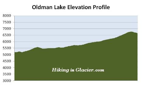
| Total Elevation Gain: | 1850 Feet | ||||
| Avg. Elev Gain / Mile: | 278 Feet | ||||
| Highest Elevation: | 6783 Feet | ||||
| Trail Difficulty Rating: | 17.00 (strenuous) | ||||
| Parking Lot Latitude | 48.49212 | ||||
| Parking Lot Longitude | -113.36561 | ||||
Trail Description:
The hike to Oldman Lake begins from the North Shore Trailhead, located in the campground at Two Medicine. To reach the trailhead from Two Medicine Road, turn into the campground and drive a half-mile along the main road. The parking area for the trail will be on your left. If this lot is full there's another small parking area located a short distance before reaching the main lot.
From the trailhead hikers will immediately cross a footbridge, and then proceed another tenth-of-a-mile to reach a trail junction. The path to the left leads to Dawson Pass, while the Pitamakan Pass Trail leads to the right. Hikers should turn right here to proceed towards Oldman Lake.
After passing around Pray Lake and the Two Medicine Campground, the trail begins to skirt around the eastern slopes of Rising Wolf Mountain.
 Roughly 2.3 miles from the trailhead hikers will cross a footbridge over Dry Fork Creek. After walking another two-tenths of a mile you'll arrive at the Dry Fork Trail junction. A turn to the right here will lead hikers down to the Two Medicine Entrance Station. To continue on towards Oldman Lake you should turn left here. At this point you'll be on the north side of Rising Wolf Mountain where the trail begins a westerly course through a broad valley, and will travel over relatively flat terrain over the next two miles or so. Throughout this section the footpath alternates between large open meadows, mixed pine forests, and a couple of small aspen groves.
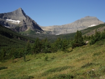
At 4.2 miles the trail begins traveling through a large open meadow. From this meadow you'll have commanding views of the surrounding mountains, including Flinsch Peak and Mt. Morgan as you look towards your destination almost straight ahead.
At roughly 6.3 miles you'll reach the side trail to Oldman Lake. Just prior to reaching the junction you'll pass through a very long stretch of huckleberries, which just might be one of the thickest huckleberry patches you'll find in the entire park.
 The short side path down to the lake
travels through a ghostly forest of dead whitebark pines, the result of white pine blister rust, a fungal disease that was accidentally introduced from Europe around 1900. According to a park brochure nearly half of the original whitebark pine population in Glacier is already dead. It's also estimated that more than 75% of the remaining trees are infected with the disease, and will die within the next 20 years.
The short side path down to the lake
travels through a ghostly forest of dead whitebark pines, the result of white pine blister rust, a fungal disease that was accidentally introduced from Europe around 1900. According to a park brochure nearly half of the original whitebark pine population in Glacier is already dead. It's also estimated that more than 75% of the remaining trees are infected with the disease, and will die within the next 20 years.
About two-tenths of a mile from the junction hikers will pass the Oldman Lake backcountry campground (containing four individual campsites). Your final destination is only a short distance away from this point.
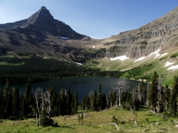
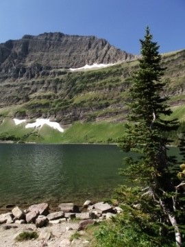
Oldman Lake is a very beautiful lake that sits at the base of 8781-foot Mt. Morgan. Flinsch Peak will dominate the view on your left, while Mt. Morgan will be due west. On your right, towards the north, is Pitamakan Pass.
If you still have the energy you'll have the option of making the 1.4-mile, and more than 750-foot climb, up to Pitamakan Pass. From the top you'll have an outstanding birds-eye view of Oldman Lake, as well as five other lakes on either side of the pass.