Mt. Brown Lookout
| Trail Features: | Outstanding views, Historic | 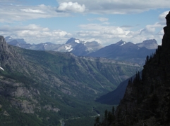 |
|||
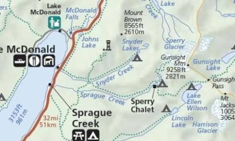
| Trail Location: | Lake McDonald Lodge | ||||
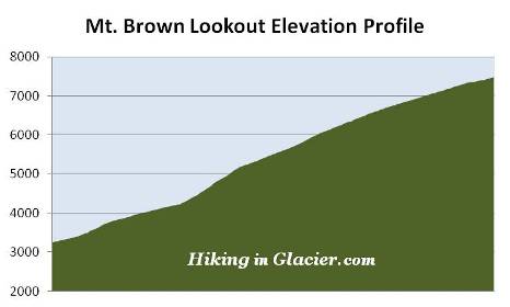
| Roundtrip Length: | 10.1 Miles | ||||
| Total Elevation Gain: | 4250 Feet | ||||
| Avg. Elev Gain / Mile: | 842 Feet | ||||
| Highest Elevation: | 7487 Feet | ||||
| Trail Difficulty Rating: | 18.60 (strenuous) | ||||
| Parking Lot Latitude | 48.61686 | ||||
| Parking Lot Longitude | -113.87554 | ||||
Trail Description:
I'm not even going to try to sugarcoat it - the hike to the Mt. Brown Lookout in Glacier National Park is a long tough slog. It climbs more than 4200 feet in just 5 miles, making it one of the toughest hikes in the park. Moreover, there are no easy sections on this hike; it's a constant climb to the top. However, there is a huge payoff, as views from the top are simply spectacular, making the effort well worth it.
The hike to the Mt. Brown Lookout begins from the Sperry Trailhead, located across the street from the Lake McDonald Lodge. In a very short distance, after passing the horse path, the trail becomes known as the Gunsight Pass Trail.
Almost immediately the trail begins climbing, passing through an old growth forest of red cedar, western larch and hemlock along the lower elevations, to a dense spruce-fir forest as it ascends higher. Many hikers and horses will be sharing this heavily used segment of the trail as they head up to the Sperry Chalet and other points in this area.
At roughly three-quarters of a mile from the trailhead hikers will begin noticing a few burn spots from the Sprague Fire. The blaze was ignited on August 10, 2017 when lightning struck along the north side of Sprague Creek, roughly three miles from the Lake McDonald Lodge. During the two-month blaze the wildfire burned 16,982 acres, and destroyed the interior of the historic Sperry Chalet dormitory. Hikers should note that park crews have cleared thousands of trees that had fallen on trails throughout the burn area. As a result, some of these trails will have limited shade in some areas.
 Upon reaching the Mt. Brown Trail junction, roughly 1.6 miles from the trailhead, hikers will have already climbed more than 900 feet. To continue on towards the lookout hikers should turn left here.
The Mt. Brown Trail starts off pretty steeply. In fact, the steepest section on the entire hike occurs immediately after turning onto the trail. Over the next three-quarters of a mile you will have climbed almost a thousand feet!
After awhile you'll begin to feel like the hike is becoming more of a grind. It's a constant climb with virtually no flat spots to regain your breath. The total elevation gain is very similar to the amount gained on many of the 14,000-foot peaks in Colorado. If there's any consolation, however, you'll be climbing at an elevation that's only half the height of those "fourteeners", therefore breathing is actually a little bit easier.
At roughly 2.5 miles from the trailhead hikers will pass through a very long stretch of huckleberries. Throughout this section hikers should make a lot of noise to alert any bears that might be around.
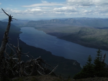
As you ascend higher vistas will begin to emerge through openings in the tree cover. At roughly 3.9 miles you'll reach a sharp bend in the trail that provides your first big views of the day. From this vantage point you'll be able to see Lake McDonald, Fish Lake and many of the surrounding mountains. This is also a pretty good place for a short break.
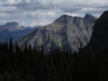
A third-of-a-mile later hikers will round another bend that offers some absolutely grand views of the mountains towards the north, including Heavens Peak. You'll also have the first views of your destination. The lookout tower will be almost directly above you from this point.
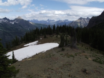
 At roughly 4.8 miles you'll finally emerge from the treeline and will be on the ridge that leads to the fire tower, which is now less than a quarter-of-a-mile away. The tough part of the hike is finally over!
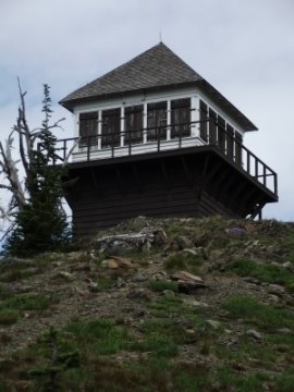
At an elevation of 7487 feet, the historic lookout tower sits on an outcropping along the southwest ridge of Mt. Brown. The summit of the mountain rises almost 1100 feet above the lookout towards the northeast.
The Mount Brown Lookout, rehabilitated in 1999, is on the National Historic Lookout Register. It was constructed in 1929, and was last manned on a full time basis in 1971. From this perch you'll enjoy commanding views of Mount Vaught, McPartland Mountain and Heavens Peak towards the north, Sperry Glacier towards the east, as well as Lake McDonald in the valley far below.
The mountain is named for William Brown, a Solicitor General for the Chicago and Alton Railroad. He and several other adventurers climbed the peak during a camping and fishing trip in 1894, making it, in all likelihood, the first ascent of the mountain. My book, Ramble On (a history of hiking), includes information on trail development in Glacier, as well as other hiking related stories from the early years of the park.