Medicine Grizzly Lake
| Trail Features: | Subalpine lake, Scenic views, Wildflowers | 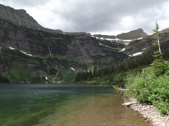 |
|||
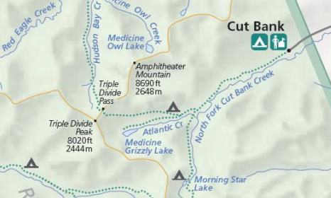
| Trail Location: | Cut Bank | ||||
| Roundtrip Length: | 12.4 Miles | ||||
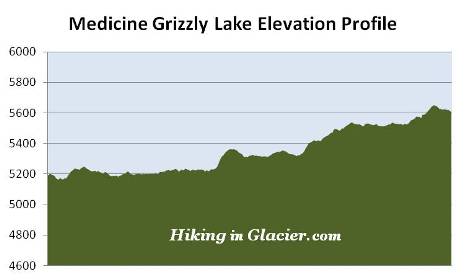
| Total Elevation Gain: | 625 Feet | ||||
| Avg. Elev Gain / Mile: | 101 Feet | ||||
| Highest Elevation: | 5651 Feet | ||||
| Trail Difficulty Rating: | 13.65 (strenuous) | ||||
| Parking Lot Latitude | 48.60242 | ||||
| Parking Lot Longitude | -113.38355 | ||||
Trail Description:
The hike to Medicine Grizzly Lake begins from Cut Bank on the east side of Glacier National Park. To reach the trailhead drive 16 miles north of East Glacier, or 13.8 miles south of St. Mary, and turn west onto Cut Bank Road. Drive another 5 miles to the end of the gravel road, just past the ranger residence building, and turn into the small parking area just off the side of the road. The hike begins from the Pitamakan Pass Trailhead.
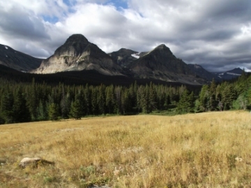 From the trailhead, as well as during the early portions of the hike, 8341-foot Mad Wolf Mountain and 8350-foot Bad Marriage Mountain will be the dominating features looking towards the south. After walking less than a quarter mile hikers will reach the North Fork Cut Bank Creek, and will more or less follow it over the course of the next several miles. Shortly after reaching the creek you'll likely notice a broad flat area choked with willows. In addition to several similar spots further up the trail, this is considered to be prime moose habitat. Gray wolves are also known to frequent this area of the park as well.
Throughout the entire hike the trail meanders in and out of conifer forests and open meadows that feature several varieties of wildflowers. During the early portions of the hike the trail also passes through several patches of thimbleberries, huckleberries, and other edible (but not so tasty) wild berries. As a result, this part of Glacier is prime grizzly bear habitat, so it's important to make a lot of noise, carry bear spray, and travel in groups of three or more.
For the most part the trail travels over relatively flat terrain; however, there are a couple of short climbs you'll have to tackle along the way.
At roughly 4 miles from the trailhead hikers will arrive at the Triple Divide Pass Trail junction. Hikers should turn right here to continue towards Medicine Grizzly Lake. From this point forward you'll more or less follow Atlantic Creek all the way to your destination.
Just beyond the junction hikers will pass the Atlantic Creek Campground (4 individual campsites). Three-quarters of a mile past the junction is the Medicine Grizzly Trail junction. Continuing along the main trail would lead you to the top of Triple Divide Pass, a climb of almost 1860 feet from this point. To continue towards Medicine Grizzly Lake hikers should turn left here.
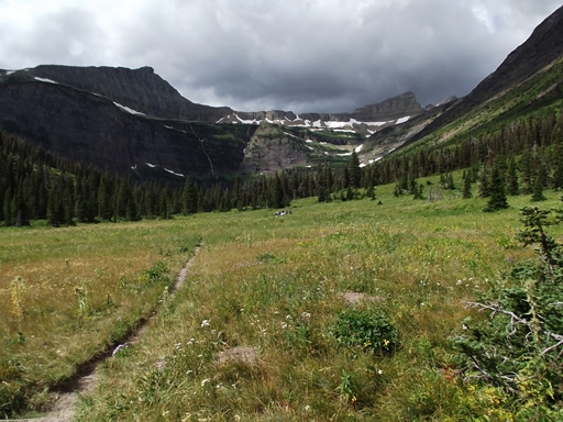
 Just before reaching the lake, roughly 5.5 miles from the trailhead, hikers will pass through an exceptionally large meadow that features a carpet of wildflowers, as well as commanding views of the Medicine Grizzly Lake basin area.
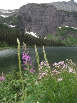
At 6.2 miles hikers will finally arrive at the northeastern shore of Medicine Grizzly Lake. According to Through The Years In Glacier National Park, the lake is named for the legendary "Medicine Grizzly" that inhabited the Cut Bank Valley, and whose story is told in Walter McClintock's Old North Trail. The bear was reportedly killed by Chance Beebe, a U.S. Biological Survey hunter from Columbia Falls, and one of the first rangers in Glacier National Park.
The lake sits in a large basin below the Continental Divide, and is surrounded by 9375-foot Mount James towards the north, 8020-foot Triple Divide Peak and Triple Divide Pass towards the northwest, and 8569-foot Razoredge Mountain towards the southwest. Look closely and you'll see at least five waterfalls cascading hundreds of feet down along the walls of these mountains as they make their way towards the lake.
Triple Divide Peak has the rare distinction of marking the spot where water flowing off the various sides of the mountain empties into three separate oceans. Known as a hydrological apex, water draining off Triple Divide Peak eventually reaches the Atlantic, Pacific or Arctic Oceans. It should be noted, however, that there's a debate among hydrologists as to whether Hudson Bay is mainly part of the Arctic Ocean or the Atlantic Ocean, with the implication that Triple Divide Peak may not be a true hydrological apex.