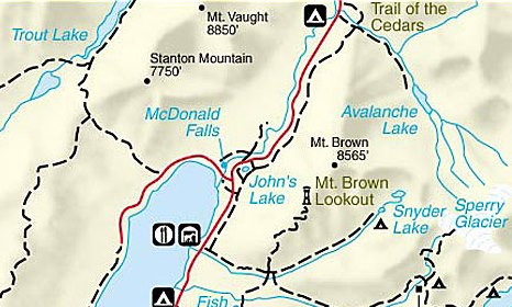
Johns Lake Loop
| Trail Features: | Waterfalls, Lake views | 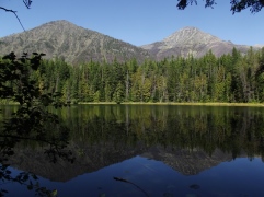 |
|||
| Trail Location: | Johns Lake Trailhead | ||||
| Roundtrip Length: | 1.8 Miles | ||||
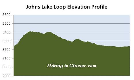
| Total Elevation Gain: | 225 Feet | ||||
| Avg. Elev Gain / Mile: | 250 Feet | ||||
| Highest Elevation: | 3410 Feet | ||||
| Trail Difficulty Rating: | 2.25 (easy) | ||||
| Parking Lot Latitude | 48.63335 | ||||
| Parking Lot Longitude | -113.86231 | ||||
Trail Description:
The Johns Lake Loop in Glacier National Park begins from the Johns Lake Trailhead, located 1.3 miles east of the Lake McDonald Lodge on the Going-to-the-Sun Road. The parking area alongside the road has space for roughly 7 or 8 cars. This fairly popular hike visits Johns Lake, Sacred Dancing Cascade and McDonald Falls. This hike description follows the loop in a counter-clockwise direction.
A hundred yards or so from the parking area hikers will reach the "Avalanche Trail" junction (not to be confused with the nearby "Avalanche Lake Trail"). Hikers should veer to the left here to continue on the Johns Lake Loop. A short distance later you'll reach a second junction. A turn to the left will put you on a horse path known as the McDonald Creek Cutoff. To continue on towards Johns Lake hikers should proceed towards the right.
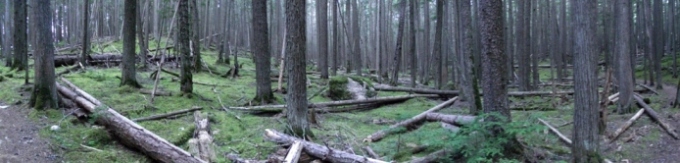
As you continue towards the lake the trail passes through a quiet old-growth forest of red cedars and hemlocks. Roughly one-third of a mile from the trailhead you'll catch a glimpse of the lake through the trees. You'll also notice a side trail that leads directly to its shore.
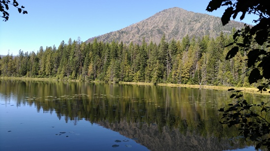
Johns Lake is surrounded by a dense forest, and its shore is lined with water lilies and wetland grasses. Forming a picture perfect backdrop against the lake is 7750-foot Stanton Mountain and 8850-foot Mount Vaught. If your timing's right you might have a nice reflection of these mountains in the water. Hikers should note, however, that the shore area is usually quite boggy, making it somewhat difficult to get close to the lake. This area is also a good place to possibly spot a moose.
A short distance from the lake, after returning to the main trail, hikers will arrive at the second Avalanche Trail junction, which veers off to the right. To continue on the loop you should proceed left to remain on the Johns Lake Trail, which now begins heading towards Sacred Dancing Cascade.
Roughly two-thirds of a mile from the trailhead hikers will reach the Going-To-The-Sun Road. After crossing the road, follow the path that leads to the Sacred Dancing Cascade parking area. This lot also provides an additional access point for this hike in case the Johns Lake Trailhead parking area is full.
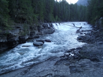 The loop hike continues by walking down to the cascade, which receives its name from a Kootenai phrase meaning "a good place to dance", or "where people dance". After soaking in the beautiful scenery, cross the fairly long footbridge and turn left once you reach the other side of the river. A turn to the right will put you on the Upper McDonald Creek Trail.
Roughly one mile from the trailhead hikers will reach a small log bench and another fork in the trail. Although there's no sign indicating the destinations for either trail, you should take the left fork to remain on the loop. Although the right fork continues along a horse path, you would eventually arrive near the same spot on the North Lake McDonald Road.
From the junction the trail continues by passing through another section of dense, old-growth forest. You'll also likely notice that the undergrowth vegetation is a deep lush green on either side of McDonald Creek throughout this area. Being situated on the eastern edge of the maritime climate of the Pacific Northwest, the Lake McDonald Valley also marks the extreme eastern limits for western hemlocks and red cedars. Some of the trees in this area are estimated to be more than 500 years old.
At just over 1.1 miles from the trailhead hikers will reach the spectacular and powerful McDonald Falls, the last feature on McDonald Creek before it empties into Lake McDonald.
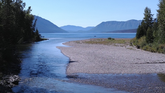
Roughly one-third of a mile past the falls you'll arrive at North Lake McDonald Road. Hikers should turn left here to continue on the loop. After a very short distance the road crosses over McDonald Creek. This bridge provides an outstanding view of the creek as it empties into Lake McDonald, as well as the Belton Hills and the Apgar Mountains on the southern and far western end of the lake.
Once on the other side of the creek, roughly 50 feet from the bridge, look for a side trail along the side of the road on your right. This narrow path leads back to the trailhead and prevents hikers from having to walk along the shoulder of the Going-To-The-Sun Road. However, don't mistake the gated gravel road for this trail, which you'll pass just before reaching the unmarked side trail. Although not needed, a detailed trail map will definitely help with navigation on this hike.