Gable Pass
| Trail Features: | Outstanding views, Alpine Meadows | 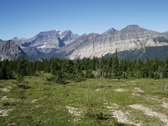 |
|||
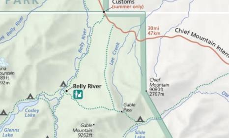
| Trail Location: | Chief Mountain International Highway (17) | ||||
| Roundtrip Length: | 13.1 Miles | ||||
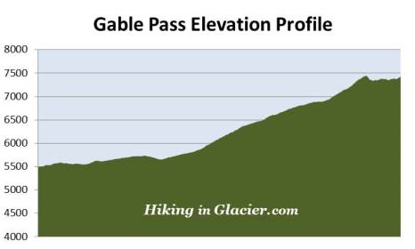
| Total Elevation Gain: | 2250 Feet | ||||
| Avg. Elev Gain / Mile: | 344 Feet | ||||
| Highest Elevation: | 7450 Feet | ||||
| Trail Difficulty Rating: | 17.6 (strenuous) | ||||
| Parking Lot Latitude | 48.98977 | ||||
| Parking Lot Longitude | -113.65199 | ||||
Trail Description:
I’m calling B.S. on this trail. No, not because of the scenery, but rather because its' apparently gone to the cows. Literally.
Finding the Lee Ridge Trailhead in the northeast corner of Glacier National Park can be a bit of an adventure in and of itself. It's very easy to miss since there's no parking lot, and the trailhead is marked with only a couple of orange and yellow plastic tags on a tree next to the road. The trailhead is located off the Chief Mountain International Highway (Hwy 17), just before reaching the Canadian border, and roughly 13.6 miles west of the Highway 89 junction.
As you approach the Canadian border look for a road sign indicating the approach of a hill. The trailhead will be on your left, just past this sign. You'll have to drive another tenth-of-a-mile to reach a small parking area on the right side of the road, which has room enough for maybe 10 cars. If you reach the Belly River parking lot you've gone too far. The coordinates for the roadside parking area are 48.99046, -113.65438 (the coordinates listed above are for the trailhead). If the parking space is full there's another parking area on the left side of the road, roughly one-tenth of a mile prior to reaching the trailhead. You'll also have the option of parking at the much larger Belly River lot if need be.
The trail starts off in a dense conifer forest. The first 2.6 miles of the hike are relatively flat, but will include some gently rolling terrain. There's quite a bit of foliage alongside the trail, with some especially long stretches of thimbleberries, making this a good place to make a lot of noise to warn any bears of your presence.
As we passed through the quiet forest on an early fall day we could hear the bugling of an elk in the direction of the Belly River area.
I don't know if it's like this all the time, but we saw several dozen cows on the road near the Glacier National Park entrance sign. We were obviously wrong in thinking that the cattle guard at the entrance would block any of them from entering the park. During the first two miles of our hike we dodged, stepped around, and stepped-in an absolute deluge of fresh cow manure. These weren't your normal cow pies either. Some of these cows obviously had some serious intestinal issues. Not only was their mess on the ground, but in many instances it was on the foliage we walked through. Every single one of us came back with manure on are boots and legs. After a couple of miles we caught a glimpse of two cows crossing over the trail roughly 100 yards ahead of us.
 After walking roughly 2.6 miles or so you'll notice that the trail is finally beginning to gain altitude.
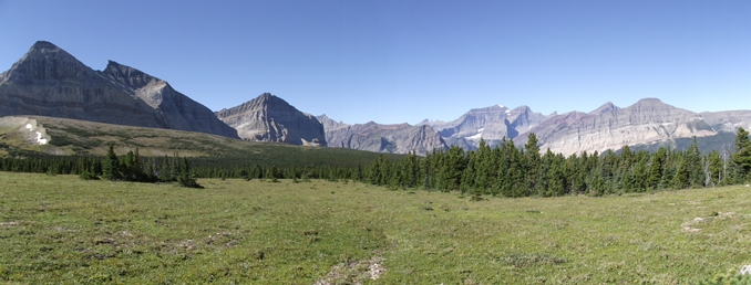
At roughly 4.4 miles scenic views will begin to emerge, and you'll be able see the mountains to the west and east of the ridge, including 9080-foot Chief Mountain. It's also around this point that you’ll lilely notice that the ridge has narrowed considerably. A short distance later the trail finally emerges above the treeline where you'll enjoy expansive panoramic views in all directions.
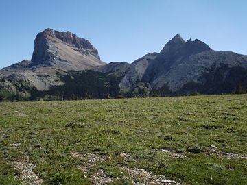
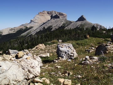
As you proceed further up Lee Ridge the trail more or less disappears into the tundra. From this point forward you'll be following cairns, which can sometimes be a bit of a challenge to locate in this rocky terrain. However, your destination is apparent, and the route is pretty easy to follow. The photo below shows the view you'll have as you proceed up the ridge. The larger mountain to the right is 9262-foot Gable Mountain. The cairns will lead you almost directly to the base of the unnamed mountain on the left.
As you ascend higher the views improve dramatically. In my opinion, these are some of the best views in Glacier National Park. The rugged mountain range towards the west includes 8841-foot Bear Mountain, 9489-foot Kaina Mountain, as well as the highest point in Glacier, 10,466-foot Mt. Cleveland. Towards the north is the Great Plains, and towards the east are Chief Mountain, Ninaki and Papoose.
In 1892 Henry L. Stimson, along with two companions, likely became the first non-Natives to climb Chief Mountain. Several years later Stimson would serve as Secretary of State (1929–1933) under President Herbert Hoover, and then as Secretary of War (1940–1945) under Franklin D. Roosevelt during World War II.
Further up on Lee Ridge we saw a small herd of roughly 15 cows roaming the area several hundred yards ahead of us. They kept their distance as we continued to move up the trail. We concluded that we likely followed this group from near the start of our hike, while they literally left a trail of fresh manure in their wake.
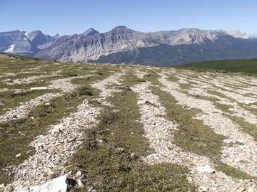
As you continue to ascend along the ridge you'll likely notice the interesting patterns in the terrain. It looks as if a landscape architect laid gravel stripes along the tundra.
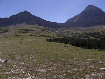
As you proceed higher you'll also likely notice that the last half-mile to the Gable Pass Trail junction becomes very steep, with the last quarter-mile being extremely steep.

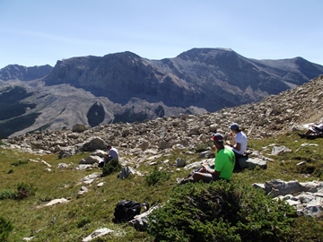
At 6 miles hikers will arrive at the Gable Pass Trail junction. Although the actual pass is still more than a half-mile away, the views from the junction are quite spectacular, and in my opinion, probably better than what you'll see at the pass. If you feel that the climb has taxed your body enough, this would be a great place to end your hike.
From the junction you'll turn left onto the Gable Pass Trail. Almost immediately the trail makes a steep drop into a basin. As it traverses towards the pass it travels through a large boulder field, mostly rocks that have tumbled off the unnamed mountain above known as Point 8445 on topographic maps.
 A little over 6.5 miles hikers will finally reach Gable Pass. Here you'll notice a fairly large cairn off to the side of the trail. Just off to the right will be a rocky area where you can climb up and over to find a spot to soak-in the outstanding views of 8665-foot Yellow Mountain, which dominates the landscape directly across the valley. To the left of Yellow Mountain is 8609-foot Sherburne Peak, while below is the Otatso Creek Valley where Slide Lake is located.
Far below the pass, and to the west of Slide Lake (but well off the main trail), are the ruins of the old Van Pelt Mine in the middle of a beautiful open meadow. Although it operated for roughly 15 years, the mine yielded very little ore. Today the site retains several archeological artifacts, including cabin ruins and mine workings from the early 1900s when John Van Pelt conducted most of his work. For safety reasons the park closed a 33-foot deep shaft at the site in 2010.