Dawson Pass
| Trail Features: | Outstanding views | 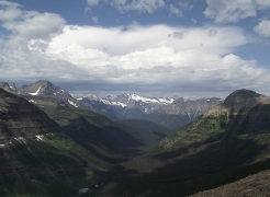 |
|||
| Trail Location: | Two Medicine Boat Dock | ||||
| Roundtrip Length: | 9.4 Miles | ||||
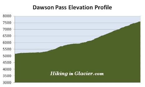
| Total Elevation Gain: | 2450 Feet | ||||
| Avg. Elev Gain / Mile: | 521 Feet | ||||
| Highest Elevation: | 7598 Feet | ||||
| Trail Difficulty Rating: | 14.30 (strenuous) | ||||
| Parking Lot Latitude | 48.48381 | ||||
| Parking Lot Longitude | -113.36954 | ||||
Trail Description:
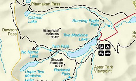
The hike to Dawson Pass in Glacier National Park begins from the North Shore Trailhead, located in the Two Medicine Lake Campground. However, you can shave roughly 4 miles off your roundtrip hike by taking the shuttle boat across Two Medicine Lake. The following describes the hike for those wishing to take the boat to the west end of the lake. Please note that there is a fee for this boat ride.
After arriving at the boat landing your hike begins with a walk along a short section of boardwalk that passes over a sensitive, boggy area. Although I've never seen one here, this is likely a good place to spot a moose, especially during the morning hours. A short distance later you'll arrive at the South Shore Trail junction, which connects hikers with the Two Medicine Pass Trail. To continue towards Dawson Pass you should proceed straight ahead here.
The early portions of the hike pass through an area thick with ferns, thimbleberries and huckleberries. Although you won't be able see your destination while hiking in the woods during this segment, you will have the opportunity to see it while aboard the boat. As you approach the dock, look for the saddle, or the low point in the mountains, towards the west.
The pass is named for Thomas Dawson, a half Blackfoot Indian who served as a guide during the early days of Glacier National Park. Dawson's Blackfoot name was Little Chief, or Inuxina. The pass, therefore, is called Inuxina ozitamisohpi in the Blackfeet language. Thomas was the son of Andrew Dawson, an official for the American Fur Company at Fort Benton.
 Roughly three-quarters of a mile from the boat landing the trail crosses a footbridge. A short distance later you'll arrive at the North Shore Trail junction, which connects with the Dawson Pass Trail. Hikers should turn right here. A turn to the left leads to Twin Falls and Upper Two Medicine Lake. At 1.1 miles hikers will finally reach the Dawson Pass Trail. You should turn left at this junction.
Up to this point the trail has traveled over relatively flat terrain, but the climbing now begins in earnest.
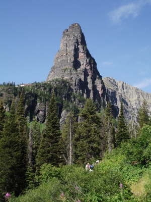
Just past the junction the towering 7620-foot Pumpelly Pillar comes into view. This glacially carved, cone-shaped rock formation is named for Raphael Pumpelly, leader of the Northern Transcontinental Railway Survey party that crossed Pitamakan Pass in 1883.
As you ascend along the Dawson Pass Trail you'll pass several more huckleberry patches. Although there may not be as many grizzly bears in the Two Medicine area as compared to other parts of Glacier, the route does pass through prime grizzly bear habitat, which means you'll still have to make a lot of noise and carry bear spray.
 Roughly two miles from the boat dock, after climbing a series of short switchbacks, the trail flattens out a bit, and remains relatively flat until reaching the side path to No Name Lake. At roughly 2.7 miles hikers will arrive at the No Name Lake Trail junction. If you wish to visit the lake, it's a short walk of only a tenth-of-a-mile to reach its northern shore. For backpackers there's a campground at the lake that contains three individual campsites.
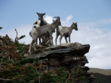
Beyond the junction the trail resumes climbing again. As you ascend the southern slopes of Flinsch Peak you'll pass through an appropriately named area known as the Bighorn Basin. On our most recent hike we saw at least twenty bighorn sheep traversing along the rocky terrain directly above us as we climbed toward the pass.
At roughly 3.9 miles from the trailhead hikers will more or less emerge above the treeline. As you approach the pass, look towards your left for a birds-eye view of No Name Lake lying several hundred feet below, as well as Two Medicine Lake further down the valley.
 At 4.7 miles hikers will finally reach the top of the pass. Sitting along the Continental Divide at an elevation of 7598 feet, Dawson Pass forms the saddle between 8538-foot Mt. Helen towards the south, and 9225-foot Flinsch Peak to the north.
One can be forgiven for intentionally, or inadvertently referring to this as "Awesome Pass". Although incorrect, the nickname is actually quite appropriate. Dominating the view towards the west is 9494-foot Mt. Phillips. More than 3000 feet below its summit are the remnants of the Lupfer Glacier. Due to considerable shrinkage in recent years, Lupfer is no longer a glacier, and is now considered to be a permanent snowfield.
Sitting in the lush green valley below the pass is Nyack Creek and Nyack Lakes. The U-shaped valley through which the creek flows was carved by glaciers during the most recent ice age, which ended almost 12,000 years ago.
Hikers should be properly prepared for all the elements at Dawson Pass. The pass is famous for bone-chilling winds that frequent this area - even on warm summer days. Wind gusts in the Two Medicine area have been clocked at more than 100 miles per hour. Hikers should dress appropriately, and may want to consider using trekking poles to help with balance in the event of strong winds.
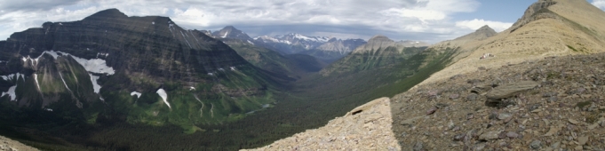
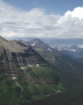
A popular option for many hikers is to continue on towards Pitamakan Pass, and then return back down to the Two Medicine Campground through the Dry Fork Valley. In the photo above Flinsch Peak is the mountain on the far right. After ascending Dawson Pass, the trail continues along the left side of this mountain, and then circles around Mt. Morgan just behind it, before reaching Pitamakan Pass. The total roundtrip length for this loop hike is 15.7 miles, assuming you take the shuttle boat. Additionally, you’ll have to tack on another 0.7 miles to your overall mileage if you don’t have transportation between the two trailheads. Another option is to begin and end your trip from the campground, which has a total roundtrip length of roughly 17.6 miles.