Cracker Lake
| Trail Features: | Outstanding views, Alpine lake | 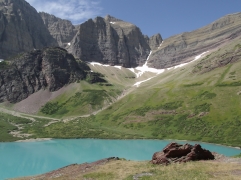 |
|||
| Trail Location: | Cracker Lake Trailhead | ||||
| Roundtrip Length: | 12.6 Miles | ||||
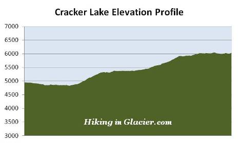
| Total Elevation Gain: | 1400 Feet | ||||
| Avg. Elev Gain / Mile: | 222 Feet | ||||
| Highest Elevation: | 6035 Feet | ||||
| Trail Difficulty Rating: | 15.40 (strenuous) | ||||
| Parking Lot Latitude | 48.79588 | ||||
| Parking Lot Longitude | -113.65556 | ||||
Trail Description:
The hike to Cracker Lake in Glacier National Park begins from the Piegan Pass / Cracker Lake Trailhead, located at the south end of the parking lot above the Many Glacier Hotel. Almost immediately after starting your hike you'll reach a split in the trail. To continue towards Cracker Lake hikers should turn left at this junction.
Over the course of the first 1.7 miles you'll be sharing the trail with horses from the concessioners corral at Many Glacier. Depending on the season, this section of trail can be either extremely muddy, or it will be dusty and deeply rutted as a result of heavy horse traffic.
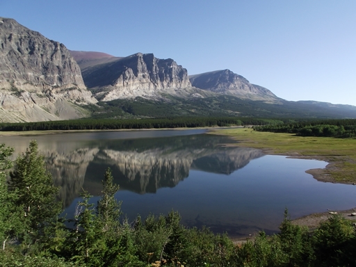
The first few miles of the hike passes through a thick forest; however, at roughly one mile from the trailhead you'll reach an opening in the canopy that provides some outstanding views of the Cracker Flats area. The mountains across the upper reaches of Lake Sherburne create a magnificent scene during the early morning hours.
At just over 1.4 miles hikers will arrive at the Cracker Flats Horse Loop. After continuing for another two-tenths of a mile you'll cross a footbridge over Allen Creek, and shortly thereafter, will reach the far end of the horse loop. To continue towards the lake hikers should proceed straight ahead at this junction.
After passing the horse loop the trail climbs a couple of switchbacks, and then begins ascending a ridge where you'll have the fairly unusual occurrence of being able to see two creeks flowing down valleys on either side of you: Allen on your right, and Canyon Creek on your left.
At roughly 2.3 miles you may catch a glimpse of an impressive waterfall flowing off the cliff straight ahead of you. It appears to tumble at least 200 feet down the cliff. Unfortunately you won't have a real clear view as the waterfall is partially hidden by trees, and the trail never gets any closer.
The Cracker Lake Trail has a long reputation for bear sightings, and for obvious reasons. It travels through prime grizzly bear habitat, passes through a lot of tall vegetation, including many berry patches, and makes a lot of twists and turns, thus creating numerous blind spots along the route. As a result, hikers should be extra vigilant on this trail. Make sure you make a lot of noise, travel in groups of three or more, and carry bear spray.
At roughly 3.25 miles from the trailhead you'll emerge from the forest. This break in the canopy offers the first views of the canyon, formed in part by the steep slopes of Allen Mountain. A little more than a half-mile from this spot you’ll cross over Canyon Creek, at which point the trail heads back into the forest for another long stretch.
At 4.75 miles the trail finally emerges from the forest for the last time. From this point forward you'll enjoy spectacular views of the deep canyon you entered a couple miles back, as well as fantastic views of your final destination. Although you won't actually be able to see the lake from this vantage point, you will be able to see the headwall between Mt. Siyeh and Allen Mountain.
At roughly 5.8 miles hikers will arrive at an overlook that provides outstanding views from the north end of Cracker Lake. If hiking on a bright sunny day, you'll immediately be struck by the most amazing turquoise color you could ever imagine. If it were possible to ignore the magnificent scenery of the surrounding mountains, it would still be well worth the hike just to see this incredibly beautiful color. You could stop at this point, but the views are even better from the red rock outcropping further up the trail. This is still another half-mile away, but well worth the effort.
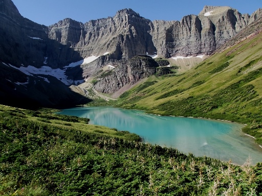
From the outcropping hikers will stand roughly one hundred feet above the lake. Directly across the basin from this perch is 9376-foot Allen Mountain. Towering above the south end of the lake is 10,014-foot Mt. Siyeh, and sitting like a gem more than 4000 feet below is Cracker Lake. The deep turquoise color of this glacially fed lake is a result of light refraction through its suspended load of glacial silt.
Hikers should also take a look at the walls surrounding the lake where you'll likely notice some really interesting sedimentary layers of multi-colored rock.
For those that still have the energy to do some additional exploring you'll have the option of continuing 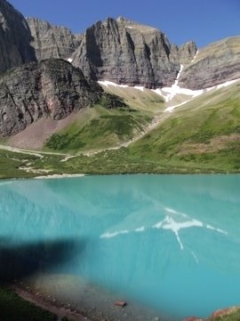 on towards the old Cracker Lake Mine site. The mine was established in 1897 after copper was discovered on the south shore of the lake. According to legend the mine received its name when two prospectors, L. C. Emmonds and Hank Norris, had a lunch of cheese and crackers on the site after staking their claim.
Although miners dug a thirteen hundred foot tunnel into the mountain, and the vein looked fairly promising, a mining expert from Helena eventually determined that the site wouldn't be profitable, and discouraged further development. In addition to the tunnel the miners built a sawmill and erected a 16,000-pound steam driven concentrator to process the ore. Modern day explorers can still find mine tailings and some of the abandoned machinery around the old mine site today. Entering the mine, however, is strictly prohibited.
One of the financial backers of the Cracker Lake Mine was Dave Greenwood Altyn. A town bearing his name was built near Cracker Flats, and was active between 1898 and 1902. However, not long after the mine went bust, so did the town. The former townsite was completely buried under water after the Lake Sherburne reservoir filled the valley in 1921.
Beyond the mine the trail finally reaches the shoreline at the far end of the lake. Also, just beyond the red rock outcropping is a side trail that leads down to the backcountry campground (which includes 3 campsites). It doesn't quite go all the way to the bottom, but you could make it to the shore with a little bit of off-trail bushwhacking.
As another interesting piece of history concerning the area, a BASE jumper leapt off of Mt. Siyeh in 1997, intending to land near Cracker Lake. Almost immediately after jumping the man hit a wall and his parachute became caught on a rock roughly 400 feet below the summit. A daring rescue involving 8 rangers and several other park employees pulled the man to safety, who suffered only minor injuries.