Cobalt Lake
| Trail Features: | Scenic views, Alpine lake, Wildflowers, Falls | 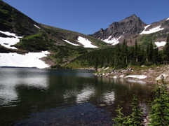 |
|||
| Trail Location: | Two Medicine (South Shore Trailhead) | ||||
| Roundtrip Length: | 11.2 Miles | ||||
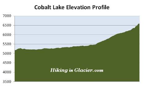
| Total Elevation Gain: | 1450 Feet | ||||
| Avg. Elev Gain / Mile: | 259 Feet | ||||
| Highest Elevation: | 6597 Feet | ||||
| Trail Difficulty Rating: | 14.10 (strenuous) | ||||
| Parking Lot Latitude | 48.48381 | ||||
| Parking Lot Longitude | -113.36954 | ||||
Trail Description:
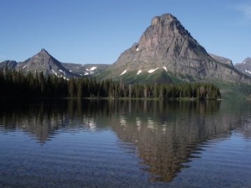 The hike to Cobalt Lake in Glacier National Park begins from the South Shore Trailhead at Two Medicine Lake. Just going to the trailhead is a worthwhile experience. The view from the eastern shore of the lake, with Painted Tepee Peak, Sinopah Mountain, Lone Walker Mountain and Mount Helen forming a picture perfect backdrop, is one of the most beautiful scenes in the entire park.
At just over a quarter-of-a-mile from the trailhead hikers will reach the side trail to Paradise Point, a small beach area that offers commanding views of Two Medicine Lake and Rising Wolf Mountain.
Roughly one-half mile from the trailhead hikers will arrive at the first in a series of small beaver ponds. This area, over the next quarter mile or so, is prime habitat for moose, which are frequently seen foraging in and around the ponds, especially in the mornings and late afternoons. As you proceed beyond the ponds the trail continues by traveling through a montane forest of lodgepole pine, spruce and Douglass fir, with several small and large meadows interspersed along the way. On our most recent hike we saw a large bull moose foraging in the woods just below Rockwell Falls.
At 1.1 miles hikers will cross over Aster Creek, and in a short distance will reach the side trail that leads to Aster Falls and Aster Park Overlook. To continue on towards Rockwell Falls you should proceed straight ahead at this junction.
 At roughly 2.3 miles from the trailhead hikers will reach the suspension bridge over Paradise Creek. Some people may feel a little nervous about walking over rickety suspension bridges. However, to get across without incident, simply walk slowly, stay towards the middle and keep both hands on the railings as you proceed across the bridge.
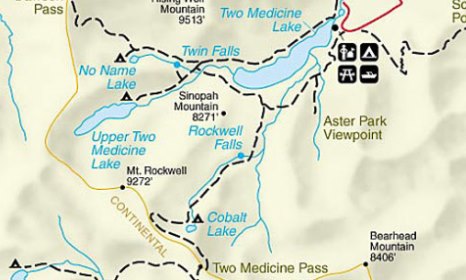
At 2.6 miles you'll reach the South Shore Trail and Two Medicine Pass Trail junction. Turning right onto the South Shore Trail will lead to the boat dock on the western shore of Two Medicine Lake where hikers will have the option of taking the boat back to the trailhead, for a fee. This trail also leads to Twin Falls and Upper Two Medicine Lake. To continue on towards Cobalt Lake hikers should turn left onto the Two Medicine Pass Trail.
Up to this point the trail has been traveling in the general direction of 8271-foot Sinopah Mountain. The trail now begins heading southward, and in the general direction of 7650-foot Painted Tepee Peak.
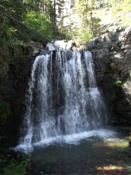
At just under 3.5 miles you'll cross over another footbridge. The trail then makes a turn towards the right, and in a very short distance you'll arrive near the base of Rockwell Falls.
Rockwell Falls actually consists of two separate falls. The waterfall most visible from the trail drops roughly 30 or 40 feet. There's another fall, roughly equal in height, located about 100 feet behind the main falls. Due to the angle and the trees, this waterfall is a little more difficult to see. However, if you don't mind a little bushwhacking, you will have access to a better viewpoint a little further up the trail.
 Up to this point hikers have only seen a gradual rise in elevation. Once past the falls, however, the trail begins climbing a series of switchbacks that lead hikers into the glacially-carved, U-shaped valley between Painted Tepee and Sinopah Mountain. You can see this geological history from the trailhead (in the photo near the top).
Just above the falls the trail also passes through an extended patch of huckleberries. This is a good place to make a lot of noise to let any bears know you're passing through. If your timing's right and the berries are ripe, this is also a good place to grab a tasty snack before visiting Cobalt Lake.
As you climb higher the trail passes into the subalpine zone, characterized by dwarf trees, beautiful meadows and numerous wildflowers.
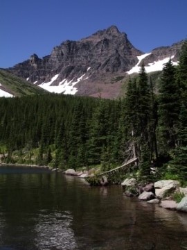
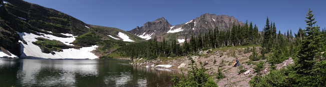
At just over 5.5 miles from the trailhead, after making a short, but relatively steep climb, the trail finally tops out at its highest elevation. From here it's only a short walk down to the shore of Cobalt Lake, which lies in a basin just below 7682-foot Chief Lodgepole Peak, located directly south of the lake.
In my opinion the views are much better from the southern and eastern shores of the lake, located just beyond the Cobalt Lake Backcountry Campground (two campsites). For photographers, 9272-foot Mt. Rockwell and Sinopah Mountain form a scenic backdrop behind the lake.
The Two Medicine Pass Trail continues beyond Cobalt Lake, heading west for a stretch before swinging southeast and tracking just below the summit of Chief Lodgepole Peak. Once on the southeastern side of the peak the trail traverses over Two Medicine Pass before dropping rapidly into the Upper Park Creek valley.