Belly River Ranger Station
| Trail Features: | Outstanding Views, History | 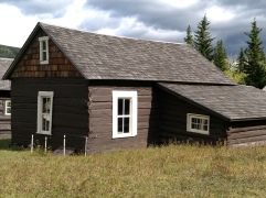 |
|||
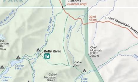
| Trail Location: | Belly River Trailhead | ||||
| Roundtrip Length: | 12.2 Miles | ||||
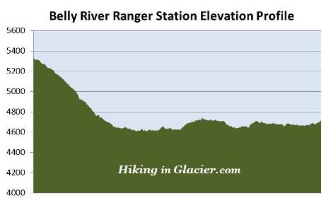
| Total Elevation Gain: | 915 Feet | ||||
| Avg. Elev Gain / Mile: | 150 Feet | ||||
| Highest Elevation: | 5325 Feet | ||||
| Trail Difficulty Rating: | 14.03 (strenuous) | ||||
| Parking Lot Latitude | 48.99595 | ||||
| Parking Lot Longitude | -113.65985 | ||||
Trail Description:
The hike to the Belly River Ranger Station in Glacier National Park begins from the Belly River Trailhead, located on the Chief Mountain International Highway (Hwy 17) just before reaching the Canadian border, roughly 13.8 miles west of the Highway 89 junction.
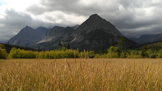
From the fairly large parking area the trail immediately begins descending through a dense lodgepole pine forest. As it continues its descent towards the Belly River Valley the forest transforms to a mix of evergreens and aspens. After walking roughly two-thirds of a mile, hikers will enjoy their first views of the mountains towards the southwest. Views of these mountains will become even more prominent as you approach the river and proceed along the valley floor.
The Belly River Trail also serves as the final segment of the Continental Divide Trail, which travels along the Rocky Mountains from Mexico to Canada. This section of the CDT actually serves as an alternate route, which thru-hikers can use to reach the Canadian border when the official designated route is snowbound. The designated route travels from the Many Glacier area via the Highline Trail, and eventually passes through Goat Haunt before reaching Waterton Park.
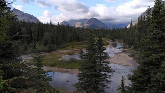
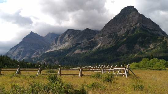
At roughly 2.25 miles hikers will reach the Belly River for the first time. Upon reaching the valley floor the trail begins to travel between pockets of forested areas and expansive meadows that offer sweeping views of the surrounding terrain. 8245-foot Sentinel Mountain and 8841-foot Bear Mountain will dominate the views towards west (on your right) as you proceed along this stretch.
Much of the Belly River Trail travels through prime bear, wolf, elk, deer and moose habitat. The proliferation of aspens along the route also makes this a great choice for a fall hike. Hikers should note that after long periods of rain the trail can be very muddy in places. You should also note that there will likely be a lot of mosquitoes along the river during the late spring and early summer periods.
At just under 6 miles hikers will arrive at the side trail that leads to the Gable Creek backcountry campground. Just beyond this junction is the Cosley Lake Cutoff Trail, which leads to Cosley Lake and Stoney Indian Pass. At this juncture hikers will have the option of walking down this path for roughly 0.15 miles to cross over the longest suspension bridge in the park. The footbridge appears to span more than 80 feet to cross over the Belly River.
Just beyond the junction the trail passes through a wooden fence, and almost immediately will reach another fork in the trail. From this junction the Gable Pass Trail proceeds towards the left, while the Belly River Ranger Station Trail proceeds towards the right to visit Elizabeth Lake and other points beyond. To continue to the ranger station hikers should turn left here and proceed for a very short distance to reach the historic Belly River Ranger Station.
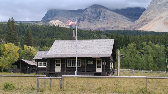
The first building hikers will encounter as they approach the historic district is the current Belly River Ranger Station, which was constructed between 1925 and 1926. This building replaced the original station, which was constructed in 1912, just two years after the establishment of the park. The Belly River Ranger Station is now one of the oldest continually manned ranger stations in Glacier National Park. It also has the distinction of being the sole ranger station in the park to be accessible only by trail.
The original log cabin is located immediately behind the current ranger cabin, and is now used as a barn. It's assumed that it was at least partially built by Joe Cosley, who was among the first six rangers to be hired by the new park. Among an array of duties, the rangers were specifically hired to protect the park's backcountry against illegal poaching and trespassing. Cosley, a poacher himself, and who was described by the Crown of the Continent Magazine as being "fifty percent romantic and fifty percent scoundrel," eventually resorted back to his hunting and trapping ways while working as a ranger. Within four years of being hired, however, Cosley was finally caught red handed poaching within the park boundaries. Though he eluded capture for more than 15 years, he was finally arrested in 1929. Incredibly, during his trial, Cosley feigned a fatal disease, and was allowed by the park commissioner to walk free. Shortly after paying a fine Cosley put his snowshoes on and walked 30 miles to cross over the Canadian border, never to return to the park. You can read more about this legendary figure from the early years of the park in Brian McClung's book, Belly River's Famous Joe Cosley.
There are several other buildings located within the district, including a fire cache, woodshed, and the trail quarters building. In addition to seeing some of the early park history, hikers will also enjoy some absolutely spectacular views of the surrounding mountains. This includes 10,466-foot Mount Cleveland, the highest peak in the park, which rises above the horse corral towards the west. Standing above the cabins in the historic district you'll be able to see Gable Mountain towards the southeast.