Beaver Pond Loop
| Trail Features: | Meadows, Historic, Forest hike | 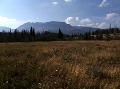 |
|||
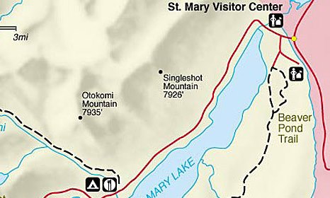
| Trail Location: | St. Mary (Historic Ranger Station) | ||||
| Roundtrip Length: | 3.6 Miles | ||||
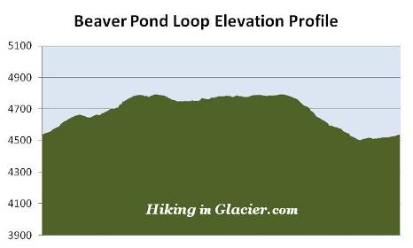
| Total Elevation Gain: | 350 Feet | ||||
| Avg. Elev Gain / Mile: | 194 Feet | ||||
| Highest Elevation: | 4795 Feet | ||||
| Trail Difficulty Rating: | 4.30 (easy) | ||||
| Parking Lot Latitude | 48.73843 | ||||
| Parking Lot Longitude | -113.43719 | ||||
Trail Description:
The Beaver Pond Loop in Glacier National Park begins from the parking area for the Historic 1913 Ranger Station, located near St. Mary. To reach the trailhead from St. Mary, turn left towards the Historic 1913 Ranger Station / Red Eagle Lake Trailhead, located between the Glacier National Park entrance sign and the St Mary Entrance Station. Drive another 0.2 miles and then veer right / go straight onto the gravel road leading towards the parking area.
The description for this hike begins from the east side of the parking area, near the Historic Ranger Station. Although the Red Eagle Trail follows along flat terrain over the course of the first half-mile, the overall topography is much easier when hiking the loop in a clockwise direction. Moreover, views of the surrounding mountains are much better while proceeding southbound on the Beaver Pond Trail segment of the loop.
I would also recommend hiking this loop in the morning, rather than later in the afternoon when the sun is high in the sky. The angle of the sun and the haze will diminish the views of the mountains towards the south and west.
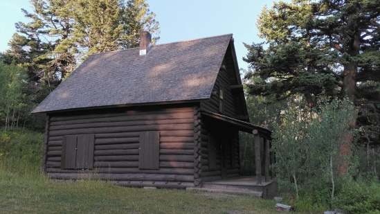
A little more than a tenth-of-a-mile from the trailhead hikers will reach the site of the Historic Ranger Station, which also includes a log barn. Built in 1913, the ranger station was among the first Park Service structures on the east side of the park. It served as permanent housing, and later as seasonal housing, for rangers until 1969. In 1972 the ranger station was added to the National Register of Historic Places, and in 1976 was restored back to its ~1913-1920 appearance. The historic site is also home to the Lubec Barn. Originally constructed in 1926 at the Lubec Ranger Station on the southern border of the park, the barn was dismantled and rebuilt at this location in 1977.
Beyond the historic site the Beaver Pond Trail passes through an old-growth conifer forest as it ascends a low ridge. Roughly one mile from the trailhead hikers will begin passing through the ghostly remnants of the Red Eagle Fire, which scorched more than 34,000 acres in Glacier National Park and Blackfeet Tribal Lands during the summer of 2006.
Once atop the ridge the terrain begins to level out. From here the trail alternates between open grassy fields and aspen groves. During the late spring and early summer you'll find a wide variety of wildflowers blooming throughout many portions of this hike, especially in the meadows atop the ridge.
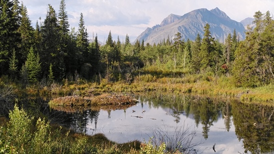
Less than 1.5 miles from the trailhead hikers will reach the beaver pond from which the trail receives its name. If you walk another 100 yards up the trail you'll find a short spur trail that leads down to the marshy shore. This is excellent moose habitat, so keep your eyes open for one foraging near the pond, especially during the morning and evening hours.
At roughly 1.9 miles hikers will arrive at the Red Eagle Trail junction. A turn to the left would lead you to Red Eagle Lake, roughly 6 miles away. To continue on the loop hike and return to the parking area, hikers should turn right here.
After passing through several more open fields the trail enters another area that was impacted by the 2006 wildfire. Along this stretch you’ll likely notice many burned tree trunks.
Soon afterwards the trail begins to descend towards the shores of St. Mary Lake. As the trail proceeds downhill it passes through pine forests, a couple of small aspen groves, as well as several large thimbleberry patches.
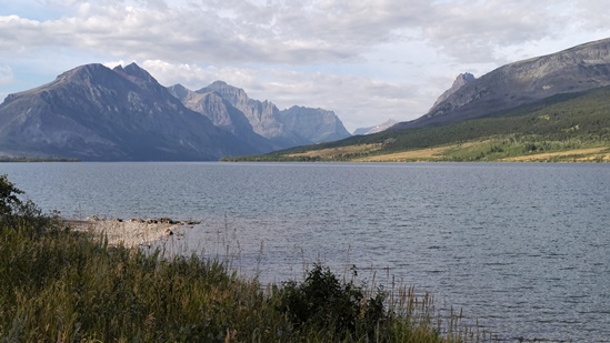
At 3.2 miles hikers will reach the side trail that leads to the St. Mary Lake shoreline. A short walk down this path offers hikers outstanding views of the lake and the surrounding mountains. This is also a great spot for a picnic, or to simply soak in the grand views before walking the short distance back to the trailhead.
Once you return back to the main trail hikers will pass another small beaver pond off to your right, just before ending your hike at the Historic Ranger Station parking area.
The Beaver Pond Loop receives relatively few visitors, thus is a good hike for finding some relative solitude. It's also one of first trails in the park to be free of snow in the spring.