Avalanche Lake
| Trail Features: | Lake, Waterfalls | 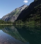 |
|||
| Trail Location: | Avalanche Creek | ||||
| Roundtrip Length: | 4.5 Miles | ||||
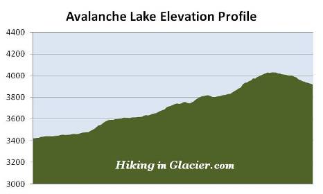
| Total Elevation Gain: | 730 Feet | ||||
| Avg. Elev Gain / Mile: | 324 Feet | ||||
| Highest Elevation: | 4031 Feet | ||||
| Trail Difficulty Rating: | 5.96 (moderate) | ||||
| Parking Lot Latitude | 48.6806 | ||||
| Parking Lot Longitude | -113.81923 | ||||
Trail Description:
The hike to Avalanche Lake in Glacier National Park begins from the Trail of the Cedars Trailhead, located 5.5 miles east of the Lake McDonald Lodge.
The Trail of the Cedars, a wheelchair accessible trail, is a loop hike that begins and ends along the Going-to-the-Sun Road. Although the western segment of the loop is slightly shorter, the eastern side is far more scenic. Hikers on the eastern portion of the loop travel along a raised boardwalk as they pass through a forest of ancient western hemlocks and red cedars. Situated on the eastern edge of the maritime climate of the Pacific Northwest, the Lake McDonald Valley also marks the extreme eastern limits for these trees. The humidity in this valley allows the cedars to grow to heights of 100 feet, and diameters of 4 to 7 feet. Some of the trees in this area are more than 500 years old.
 Look closely and you'll also notice the lush green of ferns and mosses growing along the forest floor. The boardwalk along this portion of the loop encourages visitors to take their time as they pass through habitat more normally found along the Pacific Coast.
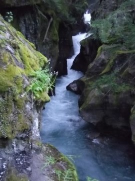
Roughly one-half mile from the trailhead hikers will reach a footbridge that spans Avalanche Creek, and provides a commanding view of the lower Avalanche Gorge, one of the highlights along this stretch of the trail. Just past this point is the Avalanche Lake Trail junction.
After turning left onto the Avalanche Lake Trail hikers will immediately encounter a short, but steep climb. As you proceed up the rise look towards your right and you'll notice a very dense forest. In less than a tenth-of-a-mile you'll arrive at the banks of Avalanche Creek. Here you'll have an up-close view of the amazing power of glacially melted water as it rushes through the narrow gorge.
At roughly 1.1 miles the trail departs from Avalanche Creek. Although no longer in direct contact, the trail continues to loosely follow the creek up to the lake. Though hikers will no longer be able to see the stream, you'll still be able to hear the rush of cascading water for much of the remainder of your hike.
Upon reaching the confluence of Hidden Creek and Avalanche Creek, roughly 1.6 miles from the Going-to-the-Sun Road, hikers will find hundreds of downed trees, the result of recent avalanches that thundered down the southern slopes of Mt. Cannon.
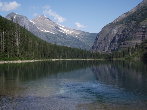
At 2.3 miles hikers will finally reach the foot of Avalanche Lake. A short distance away is a large beach area that provides plenty of space to soak-in the magnificent scenery. You'll also find several make-shift benches to rest on as well.
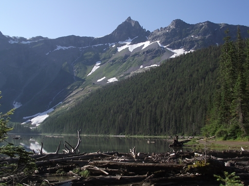
The lake sits at the base of 8694-foot Bearhat Mountain, which rises almost 4800 feet above the lake towards the northeast. The mountain dominating the view towards the south is 7886-foot Little Matterhorn. If you look closely at the cliffs and mountains that surround the lake you'll likely notice several long waterfalls plunging hundreds of feet as they make their way towards the shore. Many of these waterfalls originate from Sperry Glacier, which rests beyond Little Matterhorn and can't be seen from the lake.
For perhaps a little more solitude, as well as some varying perspectives of the surrounding mountains, hikers can continue on the trail as it follows along the western shoreline to the head of the lake.
This area of Glacier National Park was named by Dr. Lyman Sperry. While exploring the basin in June of 1895, Sperry saw and heard multiple avalanches roaring down the surrounding mountains, and agreed with his exploring party "that Avalanche Basin would be a most appropriate name for the place". On a return trip later that summer Sperry would discover the glacier that now bears his name.
In between those two visits an unnamed local resident blazed a path to Avalanche Lake, making it, in all likelihood, the first hiking trail to be constructed for tourists in the Glacier Park area. Ramble On: A History of Hiking discusses the fascinating story of why Glacier's extensive trail system was developed during the park's early years in much more detail.
If you're looking to go home with some great photographs you may want to consider starting your hike around daybreak in order to reach the lake before the sun rises above the mountains to the east, or, wait until later in the afternoon when the sun is behind you. You should also note that this is an extremely popular area, which means parking can be an issue during the middle of the day, especially during peak tourist season.