Apgar Lookout Trail
| Trail Features: | Scenic views, Historic | 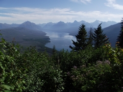 |
|||
| Trail Location: | West Entrance | ||||
| Roundtrip Length: | 7.1 Miles | ||||
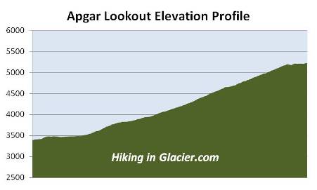
| Total Elevation Gain: | 1845 Feet | ||||
| Avg. Elev Gain / Mile: | 520 Feet | ||||
| Highest Elevation: | 5228 Feet | ||||
| Trail Difficulty Rating: | 10.79 (strenuous) | ||||
| Parking Lot Latitude | 48.50436 | ||||
| Parking Lot Longitude | -114.021 | ||||
Trail Description:
The Apgar Lookout Trail is located near the southwestern corner of Glacier National Park. To reach the trailhead from the West Glacier Entrance Station, drive north for roughly one-half mile along the Going-To-The-Sun Road and turn left towards the Glacier Institute. Drive a short distance to the next junction and turn right (away from the Glacier Institute), then almost immediately make a turn towards the left - just before reaching the Swan Mountain Outfitters horse corral. From here you'll drive another 1.9 miles along a single lane gravel road to reach the trailhead.
 The hike to the Apgar Lookout fire tower begins as an easy stroll along an old dirt road. Starting from the south side of Apgar Mountain, the trail snakes around to the west side before making a couple of long switchbacks up the southwestern slopes of the mountain. The lookout sits on an east facing ridge roughly 200 feet below the actual summit of Apgar Mountain.
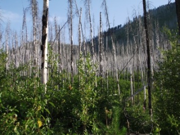
One of the first things you'll notice on this hike is the number of dead trees leftover from the massive Robert Fire of 2003. At one point this fire was so intense that flames reached a height of 500 feet along Howe Ridge (towards the north of Lake McDonald). 2003 marked the final year of a five-year drought, and became one of the worst fire seasons in Glacier National Park history. During that summer more than 136,000 acres burned within the park's boundaries. That represents 13% of the park!
Roughly three-quarters of a mile from the parking area the trail begins a steady climb up the southwestern slopes of the mountain. Over the next 2.7 miles hikers will ascend roughly 1700 feet to reach the ridge just below the lookout.
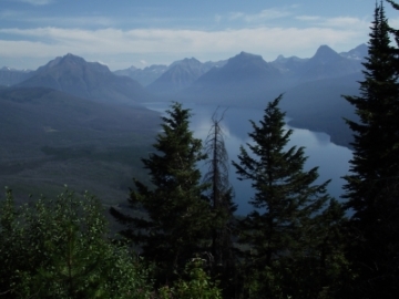 From Apgar Lookout, and the area surrounding the fire tower, hikers will enjoy grand views of the entire length of Lake McDonald, as well as the high peaks into the heart of Glacier. Unfortunately those views are partially obstructed by trees and a TV transmitter tower, but are nonetheless still spectacular.
During the early part of the day you'll be looking straight into the sun from this vantage point. The views, as well as the photo opportunities, would be much better if you waited until the afternoon to begin your hike. However, given the amount of exposure on this hike, it's likely to be much hotter in the afternoon.
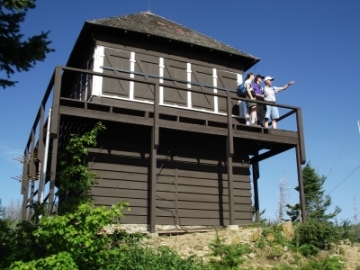 The original lookout was constructed in 1929, but burned down only two weeks after its completion. It was immediately replaced with the current two-story wood frame structure on the premises today. Although no longer in use, the fire tower is considered an historical structure, and is listed on the National Register of Historic Places. Also at the site is a TV transmitter tower that's currently being used by a Kalispell television station with a special use permit to operate within Glacier National Park.
The village, mountain, fire tower and trail are all named after Milo Apgar, who was among the first permanent families to settle on Lake McDonald in the early 1890s. Mr. Apgar built homes and cabins for tourists in this area, which would later become Apgar Village.
The Apgar Lookout Trail is also one of the first trails with great views to be snow free in the park, making this an excellent choice for an early season hike.